Hurricane Larry which is still a Category 3 storm, will avoid the Atlantic but it is to create significant swells that will start approaching the East Coast Wednesday, prompting risky surf and rip current conditions.
Severe Weather
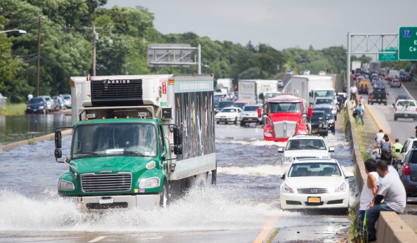
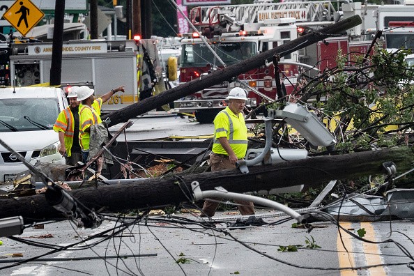
Ida's devastating toll keeps mounting across the tri-state region, which is looking at revived threats of possible severe weather like isolated tornadoes and flash floods Wednesday, as per Storm Team 4.
By mid-to-late afternoon, an approaching cold front is anticipated to prompt some light fall and thunderstorms. A few serious storms could possibly bring damaging winds and locally torrential rainfall as flash flooding will also be something to be concerned about, particularly for those still recovering from Hurricane Ida's record-breaking rainfall that took place last week.
One or two isolated tornadoes can't be out of the picture either, mostly in the western region of the city.
Most places will witness an inch of rain or less, with New York City also included, but as the ground is already 99% saturated across much of the tri-state region, any heavy rainfall that occurs, whether brief or isolated, could easily trigger flash flooding.
Places Under Flash Flood Watch
New Jersey's Bergen, Essex, Hunterdon, Union, Sussex, Middlesex, Somerset, Hudson, and Warren counties, and also New York's Orange, Rockland and Sullivan counties have been issued flash flood watches through early Thursday.
From this system, New Jersey is anticipated to see less rainfall than the portion of New York, but any extra water could cause problems. Flood warnings around portions of the Passaic River are still in effect even as the waters diminishes.
Gov. Phil Murphy made the residents of his state remember to stay safe before the storms.
Showers are anticipated to continue into Thursday morning but will diminish, starting another bright stretch of sunny weather in the high 70s - low 80s and will last through the weekend.
Hurricane Larry
Hurricane Larry, for now, a Category 3 storm that has maximum sustained winds of 115 mph according to the latest update from the National Hurricane Center, is predicted to avoid the Atlantic but tri-state coastal regions will still be impacted significantly.
Significant swells prompted by Larry will start approaching the U.S. East Coast Wednesday and will keep impacting those shores through the end of the week. There is a possibility that these will prompt life-threatening surf and rip current conditions, National Hurricane Center says.
Scientists reveal that climate change boosts the frequency of extreme weather events, with great tropical storms that swirl into potent hurricanes also included.
Bill de Blasio, the Mayor, laid out a new plan for severe weather Friday in New York City and he says it will assist the five boroughs to prepare better to fight this type of increasingly frequent disasters.
For more news, updates about Hurricane Larry and similar topics don't forget to follow Nature World News!
© 2026 NatureWorldNews.com All rights reserved. Do not reproduce without permission.


