Despite the fact that Larry is predicted to stay well east of the United States, the strong hurricane is anticipated to pass near Bermuda and AccuWeather meteorologists warn there is a possibility of it making landfall in Atlantic Canada.
But, Larry's impacts will have a wide effect although the storm could possibly stay about hundreds of miles off the Atlantic beaches from Florida to Maine.
Hurricane Larry
On Sunday Larry emerged as a very healthy and dangerous Category 3 hurricane touting a great eye and 125 mph maximum sustained winds. Larry was propelling northwestward at 13 mph and was situated 1,195 miles from Bermuda as of the evening hours.
Tyler Roys, AccuWeather Senior Meteorologist said: "While some fluctuation in strength is likely this week, Larry is forecast to gain strength and reach Category 4 hurricane status with maximum sustained winds of 130 to 156 mph, while over warm waters and minimal wind shear."
Tropical storm-force winds of 39 mph or higher stretches outward from the storm's center by 140 miles. The plunger effect of the breeze on the water was ringing about large swells that were spreading outward from the center.
As the hurricane takes a curved route to the north and northwest this week, what will lead the hurricane by several days is swells.
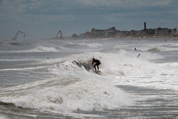
Formation of Large Waves
Roys said swells were already getting to the southeastern-facing coastline of Bermuda and the northeast-facing coastlines of the Caribbean Islands and this week they are predicted to spread northwestward.
Roys added: "Swells will then spread through the Bahamas during Monday and Tuesday, and then much of the Atlantic coast of the U.S. and Atlantic Canada during the middle and latter part of this week."
As these swells get to coastal waters, there will be formation of large waves, referred to as breakers.
With large and powerful waves impacting the beaches, water will likely rush back out to sea in small channels known as rip currents. Particularly, these currents can be dangerous to swimmers that may get caught up in the water flow.
Larry's Presence at the Sea
Despite the fact that rip currents are constantly there in wave conditions that are average, the more powerful and more regular the wave action, the more powerful and more constant the rip currents likely become. The boosted action of the wave can be enough to prompt overwash and coastal flooding during high tide.
People visiting beaches are encouraged to adhere to restrictions that officials have in place. With the number of rescuers reducing at most beaches following the Labor Day weekend, the amount of danger for swimmers will rise with Hurricane Larry present at sea.
The most unfavorable conditions in the northeastern U.S. could possibly be this week's second half, when Larry is anticipated to make its nearrest approach.
For more news, updates about Hurricane Larry and similar topics don't forget to follow Nature World News!
© 2026 NatureWorldNews.com All rights reserved. Do not reproduce without permission.


