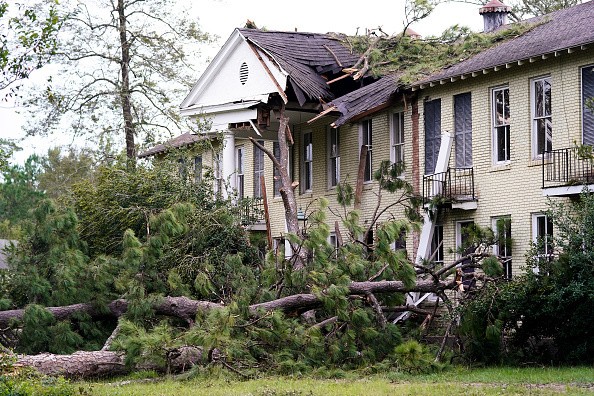
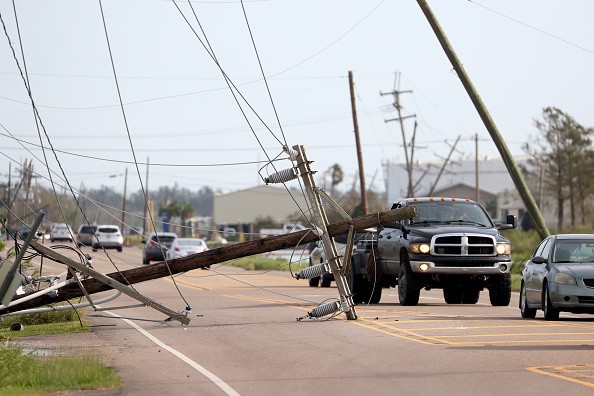
When Ida arrived ashore in Louisiana as a powerful Category 4 hurricane that had sustained winds of around 150 mph, the storm separated roofs from buildings and caused power poles to snap.
It was able to push a wall of water that has the power to move homes off its base and separate boats and barges from their moorings.
Hurricane Ida
Climate change assisted Ida in rapidly gaining strength prior to the landfall it made. In about 24 hours, Ida changed from a Category 1 to a Category 4 storm as it propelled over usually hot water in the Gulf of Mexico.
The ocean had a bathwater temperature which is around 85 degrees Fahrenheit. That should be a few degrees hotter than normal, as per National Oceanic and Atmospheric Administration's measurements.
The additional heat served as fuel for the storm. Heat is energy, therefore hurricanes that have more energy have more rapid wind speeds and great storm surges. When Earth heats up, major hurricanes like Ida which intensify rapidly have a higher chance of occurring, scientists say.
Particularly, this trend is obvious in the Atlantic Ocean, including storms like Ida that move over the Caribbean Sea's shallow, warm water. A study in 2019 discovered that hurricanes that develop in the Atlantic have a higher chance of getting powerful in no time.
Why is Hurricanes Ida Very Dangerous?
For years, people residing along the U.S. Gulf Coast have been staying with that climate reality. 2017's Hurricane Harvey, 2018's Hurricane Michael and last year's Hurricane Laura all strengthened rapidly prior to their making of landfall. Now Ida is included in that list.
Hurricanes like Ida are very dangerous since the time for people to get ready isn't much. By the time the power of the storm is evident, it can be too late for evacuation.
Water that is abnormally hot also boosts the risk of flooding from hurricanes. As Hurricanes form over the water, they absorb moisture and then release that moisture as rain. The hotter the water and air - the more water vapor gets absorbed.
Potential Rainfall
Even regions distant from the coast are prone to flooding risk. Meteorologists are warning people inhabiting the northeastward path to the Mid-Atlantic of Ida that they should brace for threatening amounts of rain. On Monday parts of central Mississippi could witness up to a foot of rain.
Hurricane Ida is an instance of what storms could be like on a warming planet, experts said. It hits the Gulf Coast on the heels of a chief United Nations report discovering powerful proof that change in climate will make hurricanes slower, rainier, and very capable of explosive development.
An expert in extreme weather at Louisiana State University named Jill Trepanier said: "Ida is another example of a changing face of hurricane intensity."
For more news, updates about Hurricane Ida and similar topics don't forget to follow Nature World News!
© 2026 NatureWorldNews.com All rights reserved. Do not reproduce without permission.


