Ida is anticipated to keep causing great damages days after it made landfall and over a thousand miles to the northeast of the place it crashed onto the soil in the United States.
After the system prompts a severe flood across some places in Tennessee and Ohio valleys, a great amount of rain will fall heavily from parts of the central Appalachians to the mid-Atlantic and New England.
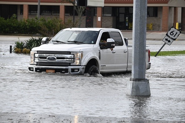
Experts claimed that life-threatening floods are also possible. The system will keep tracking to the northeast across the eastern and central United States and will lose wind intensity as it follows that path.
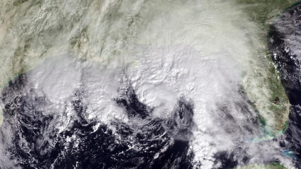
On Tuesday morning, Ida was a tropical depression possessing sustained winds of 30-mph, over northern Mississippi but there is a possibility of it being a tropical rainstorm by the time it gets to the Northeast during mid-week.
Even after Ida propels off the New England coast on Thursday, people leaving across the Northeast may still experience the wrath of the storm in the following days.
Interaction with Ida
Bernie Rayno, an AccuWeather Chief On-Air Meteorologist said there will be some interaction with Ida and a dip coming nearer in the jet stream in the northeastern United States.
Bernie added that this could make the air pressure at the center of Ida reduce. The escalation could cause even more torrential rainfall across parts of the region.
That interaction will bring about heavy rainfall and will even make up for a rapid, steady forward storm movement.
Dan Pydynowski, an AccuWeather Senior Meteorologist said: "Many areas along the path of Ida from the central Appalachians as well as parts of the mid-Atlantic and southern New England are likely to have rounds of rain over a 12- to 18-hour period, but intense rainfall can last six to eight hours."
Rainfall
Pydynowski explained that during the six- to eight-hour period, rates of rainfall that is 1-2 inches per hour can take place and it is enough to provoke flash urban and less intense stream flooding even in places where parched or average soil moisture exist.
A band of 4-8 inches of rain is predicted from southwestern Pennsylvania and northern West Virginia to the Hudson Valley of New York state, northern New Jersey, and portions of central and southern New England.
About 2 to 4 inches of rain is expected farther to the southeast. And in the two areas, pockets of more intense rain can take place with the threat of double-digit rainfall in a few instances.
Many regions across the Northeast have already experienced a wet summer ending. August rainfall has been over average to excessive in the same regions of the Northeast that Ida is predicted to affect. One and a half to thrice the usual rainfall that takes place monthly has occured in the corridor that will witness Ida's heavy rain.
For more news, updates about tropical storm Ida and similar topics don't forget to follow Nature World News!
© 2026 NatureWorldNews.com All rights reserved. Do not reproduce without permission.


