Dangerous and disastrous storms together with heavy rainfall will hit some places from the Dakotas and Nebraska to Iowa, Wisconsin, Minnesota, and Illinois through Wednesday. AccuWeather meteorologists are concerned about this.

Flash Flooding
Nicole LoBiondo, an AccuWeather Meteorologist said: "While a major outbreak of severe thunderstorms is not anticipated, the main threats from the thunderstorms will be from strong wind gusts that can reach as high as 80 mph and flash flooding in some cases."
Also, a few incidents of large hail are likely.
As per Brett Anderson, an AccuWeather Senior Meteorologist, a bubble of powerful high pressure with hot and humid air predicted to remain over Oklahoma through Wednesday will set the pattern up.
Anderson explained that both thunderstorms and showers will fire and reoccur over the northern border of this region of high pressure near the place where the jet stream will be. Major cities prone to flash flooding through midweek are Minneapolis; Sioux Falls, South Dakota; Des Moines, Iowa; Chicago and Milwaukee.
Also Read: A Series of Severe Storms Sweeping the Midwest May Trigger Tornadoes
Severe Weather
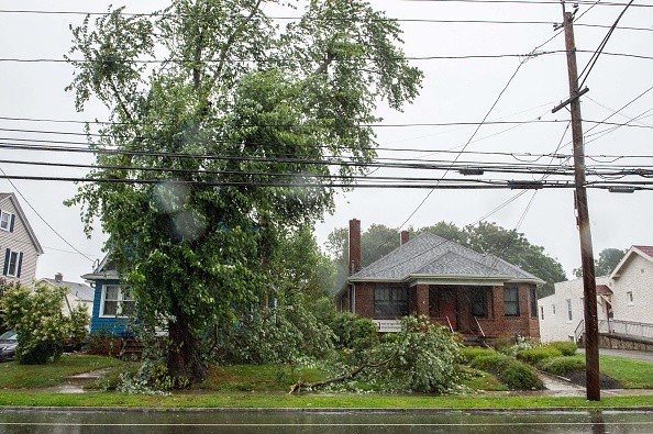
In recent days, nature has shown that a great outbreak of severe thunderstorms is not required to cause a grievous risk to lives and property, as the surprising and disatrous flash flood that took place in Waverly, Tennessee, on Saturday proofed.
What happened is an instance of what can occur when there is a repetition of complexes of drenching thunderstorms over the same region for several hours. This is a meteorological effect called "training."
At the beginning of the week, localized severe weather was reported, along with a storm in Butte County, South Dakota, releasing 80 mph wind gusts Monday evening.
In Brown County, South Dakota, a 91 mph wind gust was reported later on Monday night.
On Tuesday and the evening of Tuesday, the threat of severe storms with intense winds and heavy downpours could possibly stretch farther to the north and east and get to places in northern Wisconsin, north-central Minnesota, and some portion of western and northern Michigan.
Effect of Severe Thunderstorm
On Tuesday, this double powerful effect of severe thunderstorms and torrential rainfall may stretch from eastern and central Nebraska to northern Illinois, northern Iowa, southern Minnesota, and southern Wisconsin.
At the local level, it is this overlap region that may be most susceptible to flooding. Severe thunderstorms are predicted from eastern Montana and the western portion of the Dakotas to much of Nebraska on Wednesday.
An unconnected region of intense and gusty storms with the possibility for localized severe weather may stretch from Missouri to the Lower Peninsula of Michigan to Ohio, western New York state, and central Pennsylvania. In these two places, there will be a possibility for downpours that can produce flash flooding.
AccuWeather meteorologists are urging residents to be updated on when severe weather threatens their region and conditions can change very fast.
Related Article : Gusty Winds, Flood Caused by Severe Storms Will Rattle Nebraska to Minnesota, Wisconsin
For more news, updates about severe weather and similar topics don't forget to follow Nature World News!
© 2026 NatureWorldNews.com All rights reserved. Do not reproduce without permission.


