Over the past few weeks, wildfires have been intense in the West, and because of this, there will be threats for more fresh fires in the days to come.
Monsoonal Moisture
The major concern early in the week will be thunderstorms with dry lightning as monsoonal moisture extends farther to the north and west.
This has already been witnessed at times of the past week, with Los Angeles seeing measurable rain on Tuesday. For this time of year, that is an uncommon feat as Downtown Los Angeles only gets an average of 0.01 of an inch of rain for July.
Across Southern California, few more showers and thunderstorms were roaming again early Sunday morning. More thunderstorms will be seen farther north Sunday and Monday as a surge of moisture pulls up through California and Nevada.
The precipitable water reveals this surge well, which will possibly be sufficient to prompt some mild showers and thunderstorms, mostly across some of the higher land. Some of the less intense spots will also see one.
Dry Period of the Year
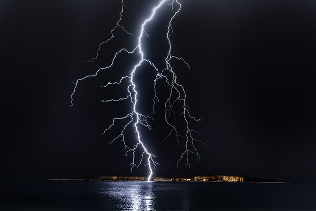
Rain can surely be an aid during this dry period of the year, and most times conditions similar to this cause more harm than good. There can be little or no rain with some of these storms, easily allowing the start of fires by lightning strikes.
Dry lightning prompted fires in August 2020, and some of those fires eventually started burning hundreds of thousands of acres.
Why does this take place? You can take a look at a forecast sounding in Reno, Nevada, on Monday in order to have an idea. Soundings similar to this enable us to get a visual glance at the atmosphere.

Blue Line Vs. Red Line
In this case, you have to observe how near the blue and red lines are to each other.
The blue line is an indication of dew points, the red line reveals the temperature as you move up through the atmosphere. Each time the lines are near, the air is nearer to saturation. Observe how there is a decent quantity of moisture in the mid-levels, but how much more parched the air is close to the surface.
Because of this, while there can be sufficient moisture to help in the development of thunderstorms, the rain from the clouds may mainly evaporate before it touches the ground. When the rain doesn't get to the land and lightning is striking already dry brush, a lot of fires can be triggered.
Also, both the GFS and the Euro are revealing the possibility of an additional surge of moisture up through California at the beginning of next week.
The European is very much aggressive with the moisture. As we head through the coming days, a close eye will be kept on that.
Related Article: Increase in Monsoon Rainfall Largely due to Natural Climate Fluctuations, not Global Warming
For more news, updates about dry lightning and similar topics don't forget to follow Nature World News!
© 2026 NatureWorldNews.com All rights reserved. Do not reproduce without permission.


