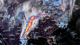
Clipper storms have a track record of dropping down thick snow precipitation from the Great Lakes region of the United States to the central Canadian province of Alberta. This storm, officially known as the Alberta clipper system, is currently threatening the Midwest and Northeast US regions this week, according to meteorologists on Monday, October 30.
The Alberta clipper, also called an Alberta low or Alberta cyclone, is threatening the said US regions with snow squalls, which is notorious for causing dangerous whiteout conditions in the past. The clipper is a fast-moving, low-pressure system that originates within or near Alberta. Following US weather forecasts about the system, early-season winter-like conditions are possible in New York, Pennsylvania, and their surrounding states.
Clipper Storm Threatens US

Weather experts on Monday reported that the quick-hitting clipper storm is raising the risk of dangerous snow squalls for motorists across the Midwest and Northeast, where major travel disruptions are expected into Wednesday, November 1. AccuWeather meteorologists warn that the cold air blast, which is typical for the winter month of December, will be accompanied by the Alberta clipper system.
The said storm is notorious not only for snow squalls but also snow flurries and lake-effect snow. This same system will then spread through midweek across the upper Midwest to the lower Great Lakes and interior Northeast, the meteorologists warned. During this period, the average temperature across the regions will drop 30 to 50 degrees Fahrenheit lower than the warm weather temperatures seen over the past week.
Also Read: Multiple Alberta Clippers May Bring Snow to Midwest, Northeast
Clipper Weather Hazards
The National Weather Service (NWS) has also reported a forecast regarding "possible" snow squalls across some areas of the northern Great Plains, upper Midwest, and Great Lakes through Halloween. In its short-range forecast at 3:59 a.m. EDT (local time) on Monday, the NWS' Weather Prediction Center (WPC) that the same clipper storm is moving in a southward pattern from south-central Canada will bring snow showers and snow squalls across the region as early as Monday.
The WPC warned that squalls may lead to high snowfall rates and quickly reduce visibility in affected areas. The prediction center specified that the system's potential lake-effect snow is likely to impact the Keweenaw Peninsula and other areas of Michigan. On the other hand, the center mentions of another storm system approaching the country's Pacific Northwest on Wednesday night, bringing localized heavy rain in some parts of northwest Oregon and western Washington states.
Potent Autumn Cold Front
Meanwhile, the weather service described a "potent autumn cold front" that is expected to spread scattered showers from the southern Plains to the Northeast on Monday. The cold front is trekking the continental US as it pushes through the Gulf Coast and East Coast by Monday night.
Since late October, meteorologists have forecasted the arrival of early-season winter storms in different parts of the US ahead of the official 2023 US winter season in December. In recent years, wintertime snow squalls with intense cold weather have disrupted New York City and other parts of the Northeast.
Related Article: Canada Weather Forecast: Clipper Systems To Unload Heavy Rain in Southern Ontario
© 2024 NatureWorldNews.com All rights reserved. Do not reproduce without permission.

![Tsunami Hazard Zones: New US Map Shows Places at Risk of Flooding and Tsunamis Amid Rising Sea Levels [NOAA]](https://1471793142.rsc.cdn77.org/data/thumbs/full/70325/280/157/50/40/tsunami-hazard-zones-new-us-map-shows-places-at-risk-of-flooding-and-tsunamis-amid-rising-sea-levels-noaa.jpg)


