The Delta Works took approximately 45 years to complete after the North Sea Flood of 1953. We shouldn't wait too long to defend The Netherlands from sea level rise.
But how much time still remains? A new formula was developed by an international team of researchers from Utrecht University, Deltares, and NIOZ, among other institutions, to determine when the likelihood of flooding in a particular area will increase.
According to the calculations, in more than a quarter of the analyzed locations, the predicted likelihood of flooding will be 10 times higher in 30 years. The study's findings were published in Nature Climate Change.
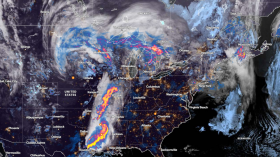
Flood Risk Will Be Ten Times Higher
![Flood Risk Caused by Sea Level Rise Will Be 10 Times Higher for the Next 30 Years [STUDY]](https://1471793142.rsc.cdn77.org/data/images/full/64483/flood-risk-caused-by-sea-level-rise-will-be-10-times-higher-for-the-next-30-years-study.jpg?w=820 "Flood Risk Caused by Sea Level Rise Will Be 10 Times Higher for the Next 30 Years [STUDY]")
Very high water levels are becoming increasingly frequent as a result of sea level rise. Floods frequently result from exceptionally high water during a storm, therefore this is an issue. As a result of the Earth's continued warming, disasters are more likely to occur, as per Phys.org.
However, scientists were unsure of the precise timing of an increase in the likelihood of flooding in particular locations.
This is due to how widely protection standards differ globally. Thus, researchers developed a novel computation technique for this investigation. They then used this technique in around 500 locations worldwide.
The calculations reveal that within the next 30 years, the anticipated likelihood of flooding will be 10 times higher in more than 25% of those locations.
Because the likelihood of flooding is not precisely known everywhere, estimates are employed. Central America, southern Europe, South Africa, and some regions of Asia and Australia are where the growth is happening the fastest.
The Dutch province of North Holland is also taken into account in the computations. The chance of flooding at a water level that now only happens once every thousand years serves as the criterion for the coastal fortifications around the city of Den Helder.
According to the new method, sea level rise will cause this water level to occur 100 times more frequently on average in 2116. So, the likelihood of flooding in the area of Den Helder increases significantly.
Knowing when a rise in the likelihood of flooding may occur, say the researchers, is crucial. "Planning and executing new adaptation measures takes time.
For example, it took decades to accomplish the Delta Works following the North Sea Flood of 1953, even though the plans were there already," explains Marjolijn Haasnoot, a climate adaptation expert at Deltares and Utrecht University.
Policymakers can now see how much time is available to implement such policies in various locations thanks to their new estimates. Such knowledge is crucial for planning adaptations.
The height of extreme water levels is frequently used to determine the height of dikes and other obstacles. The degree of protection increases with decreasing probability of exceeding the maximum water level the dike can bear. The criteria for the likelihood that dikes may flood varies greatly across the Netherlands.
The greatest likelihood of flooding in places near The Hague and Rotterdam is lower, at once every 10,000 to 30,000 years, but the lower limit is a probability of flooding once every 1,000 years in most locations on the northern shore and in Zeeland.
Ameland and Zeeuws-Vlaanderen, on the other hand, have greater maximum probabilities. The level of protection varies greatly across the globe as well.
Also Read: Heavy Rain Threatens 1,200-Mile Area with Flash Flood Risk from Kansas to West Virginia This Week
What Causes The Rise In Sea Levels?
Since 1880, the planet has warmed by 1°C (2°F). Because the ocean absorbs more than 90% of the extra heat that greenhouse gases trap in the atmosphere, the ocean's surface temperature increased by around 1.5°F over that time, as per WHOI.
The main cause of sea level rise over the past century was the thermal expansion of water, which causes warmer water to take up more space.
Sea levels rise as a result of meltwater from the world's melting glaciers and ice sheets, which is currently the primary cause of sea level rise on a global scale.
Warmer ocean water erodes ice shelves from the sides and below while hotter air melts the ice's surface, causing additional ice and meltwater to flow into the sea.
The largest ice sheet in the world, Greenland, is melting four times more quickly than it did in 2003 and is to blame for 20% of the current rise in sea level.
According to IPCC estimates, Greenland could raise sea levels by 3.1 to 10.6 inches (8 to 27 cm) by 2100, and Antarctic ice loss could raise sea levels by an additional 1.2 to 11 inches (3 to 28 cm).
Subsistence, or when land sinks or settles as a result of natural geologic processes and man-made factors such as pumping water out of aquifers, is another cause of rising sea levels.
Over the world, flooding is made worse by coastal survival and sea level rise, endangering densely populated areas.
Related article: Tropical Moisture to Bring Wet Weather and Flood Risk to the Southern US by End of Week
© 2024 NatureWorldNews.com All rights reserved. Do not reproduce without permission.