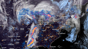
Residents from the central Gulf Coast to the coastal Carolinas should be on the lookout for worsening conditions as a developing storm that AccuWeather experts believe could bring heavy rain and thunderstorms to the southern Plains move eastward late in the week.

Florida to Feel the Storm's Full Impact
Along the Gulf and Atlantic coasts, a front will form along the southern border of the colder air. This front will provide a route for the impending storm.
Florida will be one of the first regions to experience the full consequences of the storm as it develops. Rain and thunderstorms will develop in northern Florida on Thursday night before spreading across most of the peninsula on Friday.
Flooding will be the main issue as a result of the heavy rains, although some thunderstorms may get severe locally.
Due to the rain and potential lightning, outdoor activities may be canceled or postponed. Heavy rain may also cause traffic congestion on highways by limiting visibility and raising the danger of hydroplaning at high speeds. Rain and storms may drive some who want to start their weekend at the beach back inside.
Thundery northeast winds will stir up strong waves and the potential of flash flood in certain coastal regions. This will heavily affect the east-facing shores of Florida and North Carolina's Outer Banks.
Also Read: Tropical Storm in the Philippines Leaves 13 People Dead and 9 Missing
Potential Flooding in Southeast Coast
Another component will play a role, particularly in the Carolinas, perhaps resulting in catastrophic coastal flooding. King tides, or higher-than-normal tides, are forecast throughout the Southeast coast towards the end of this week.
The storm's onshore flow and severe surf, along with the extremely high astronomical tides, which generally cause modest coastal flooding, might generate catastrophic coastal flooding.
Marinas, streets, and buildings near the coast in places like Charleston, South Carolina, and Savannah, Georgia, might be submerged. Flooding might aggravate if heavy rain reaches the Carolina beaches, particularly during high tide, since precipitation is unable to adequately flow into the ocean.
However, with most of the rain continuing offshore, coastal flooding may be the sole danger for much of the Southeast coast.
Another option, according to AccuWeather forecasts, might emerge as the storm progresses. While this would not have a large influence on possible consequences, it might encourage forecasters to use the additional name list for the Atlantic hurricane season in 2021.

Adria: The First Name on the Supplemental List
The World Meteorological Organization introduced the list last spring as a substitute for the Greek alphabet, which meteorologists had previously used to name tropical storms after the official list of storm names had been exhausted.
Wanda was the final name on the initial Atlantic name list for 2021, It formed this past weekend. The first name on the supplemental list is Adria.
Highs in the 50s and 60s F are expected for much of the Southeast on Friday and Saturday. On both days, temperatures will be 10-15 degrees below average in certain areas.
The highs in Atlanta are anticipated to stay in the 50s through Sunday. For this time of year, the average high temperature is in the upper 60s. A frost may hit sections of northern Georgia, upstate South Carolina, and western North Carolina late Friday night or early Saturday morning.
The coastal storm will have passed through the area by Sunday, and the Southeast will begin to see a cooling trend that will extend into next week.
Related Article: Tropical Storm Fred's Flood and Strong Winds Left Trail of Destruction in Georgia, Carolinas
For more news, updates about storms and similar topics don't forget to follow Nature World News!
© 2024 NatureWorldNews.com All rights reserved. Do not reproduce without permission.


![Climate Change is Reducing Dust Levels Worldwide as Arctic Temperature Warms [Study]](https://1471793142.rsc.cdn77.org/data/thumbs/full/70320/280/157/50/40/climate-change-is-reducing-dust-levels-worldwide-as-arctic-temperature-warms-study.jpg)