While still recovering from the damages brought by Tropical Cyclone Kalmaegi (Tino), Philipines is once again facing a potentially catastrophic weather event as Super Typhoon Fung-Wong (locally called Uwan) approaches with a circulation estimated to span around 1,500 kilometers—roughly equivalent to the length of the archipelago itself.
According to the Philippine Atmospheric, Geophysical and Astronomical Services Administration (PAGASA), the storm's vast reach means almost every region could experience strong winds, heavy rainfall, and flooding. With sustained winds of about 185 km/h and gusts exceeding 230 km/h, Fung-Wong is classified among the strongest storms of the year, prompting mass evacuations and disaster preparations across Luzon and the Visayas.
Comparing Typhoon Fung-Wong (Uwan) to Typhoon Haiyan (Yolanda)
Experts are drawing comparisons between Fung-Wong and Typhoon Haiyan (Yolanda), which devastated the Philippines on November 8, 2013. Haiyan remains one of the most powerful tropical cyclones ever recorded, striking with sustained winds near 314 km/h and gusts exceeding 370 km/h. It claimed more than 6,300 lives and displaced millions, especially in Leyte and Samar.
Fung-Wong, while not quite as intense in wind speed, poses a different kind of threat—its immense size. Whereas Haiyan's core was compact but incredibly destructive, Fung-Wong's diameter stretches nearly the width of the country, meaning more provinces will be simultaneously affected by its outer rainbands, storm surges, and flooding.
In terms of destructive potential, Haiyan's smaller but more deadly core caused localized devastation, with extreme storm surges up to 7 meters high, flattening coastal communities like Tacloban. Fung-Wong, on the other hand, is expected to generate storm surges up to five meters in several coastal areas, accompanied by relentless rainfall that could trigger flash floods and landslides over a much wider area.
In short, Haiyan was more intense, but Fung-Wong is more expansive, spreading moderate to severe conditions across an enormous portion of the nation.
Preparations and the Arrival of Storm Chasers
AP News reported that authorities have already evacuated nearly a million residents from high-risk zones in Bicol, Aurora, and Northern Luzon. With Signal No. 5 raised in multiple provinces, the government has suspended classes, cancelled flights, and closed seaports. President Ferdinand Marcos Jr. has placed several regions under a state of calamity to accelerate emergency response and resource deployment.
International storm chasers, including renowned experts Josh Morgerman, Jordan Hall, James Reynolds, and Mark Thomas, have arrived in the Philippines to document Fung-Wong's impact firsthand. They are currently stationed in Aurora province, one of the projected landfall points, GMA Network reported.
Their presence underscores how significant this storm is to meteorologists worldwide—comparable in global attention to Haiyan's historic landfall in 2013. Both Morgerman and Reynolds have warned through social media that Fung-Wong's wind field could lead to a "nationwide disaster footprint," even if its core weakens slightly before landfall.
What to Expect
Meteorologists warn that the typhoon's broad circulation could dump between 100 and 200 millimeters of rain across central and northern Luzon, with localized totals far higher. Widespread flooding, coastal inundation, and landslides are highly likely, especially in saturated and mountainous regions. Authorities are urging residents to stay indoors, secure their homes, and move to designated evacuation centers immediately.
Although the Philippines has faced hundreds of tropical storms in recent decades, the combination of Fung-Wong's size, timing, and the country's current recovery from Typhoon Kalmaegi makes this a particularly dangerous situation. Even if its maximum winds don't reach Haiyan's record levels, the scope of potential damage may be just as severe due to the storm's far-reaching effects.
Key Risks & What to Watch
- Storm surge along eastern and northern coasts: With narrow bays and low-lying residential areas, a surge of up to ~5 m could inundate communities.
- Heavy rainfall & flooding inland: Rainbands from Fung-Wong may drop 100-200 mm or more, triggering flash floods and landslides, especially in mountainous regions.
- Widespread wind damage: While the sustained winds may not match Haiyan's peak, the storm's size means many areas will endure damaging gusts, uprooted trees, power outages, and structural damage.
- Compound hazard context: The Philippines has recently been hit by other storms (such as Typhoon Kalmaegi) and many communities are still recovering — weakened infrastructure, saturated soil,s and vulnerable shelters raise the stakes.
- Rapid intensification risk: Meteorologists warn Fung-Wong may strengthen quickly as it approaches the Philippine Sea; this leaves less time for last-minute preparations.
What Residents Should Do
- Evacuate immediately if instructed by local government units — do not wait until wind and rain become extreme.
- Move away from coastal zones, riverbanks, known landslide-prone slopes, and high-risk bridges.
- Secure property as best as possible: tie down loose objects, clear gutters/drains, and reinforce windows if possible.
- Stock basic emergency supplies (food, water, medicines, power bank, torch) and stay in touch with official updates.
- Avoid non-essential travel once storm signals are raised, especially by sea/river.
- After the storm, report damage to authorities, avoid walking in floodwaters (they may be contaminated or pose hidden hazards), and await official clearance before returning to evacuated areas.
Why This Storm Commands Attention
Though less extreme than Haiyan in terms of peak wind speed, Fung-Wong's sheer scale and timing make it especially dangerous for the Philippines. A large storm affects many more people, amplifies secondary impacts (rain-flood-landslide-surge cascade), and strains evacuation/logistics across more regions. Coupled with the reuse of resources (post-Kalmaegi) and recovery fatigue, the risk profile is elevated.
As storm chasers arrive and the global media watches, local authorities and communities must treat this as a full-on disaster preparedness event — not just another typhoon. The coming 24-48 hours will be critical.
As Fung-Wong continues its westward path, the world watches once more as the Philippines braces for a disaster of massive proportions—a storm so vast that it could blanket the entire country in its fury.
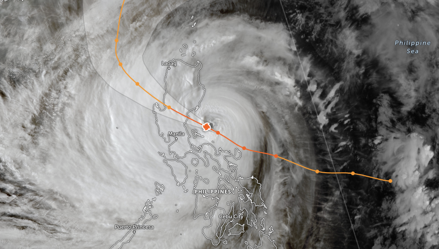
Here's a live tracker showing where Super Typhoon Fung-Wong is heading:
Originally published on Science Times
© 2025 ScienceTimes.com All rights reserved. Do not reproduce without permission. The window to the world of Science Times.


