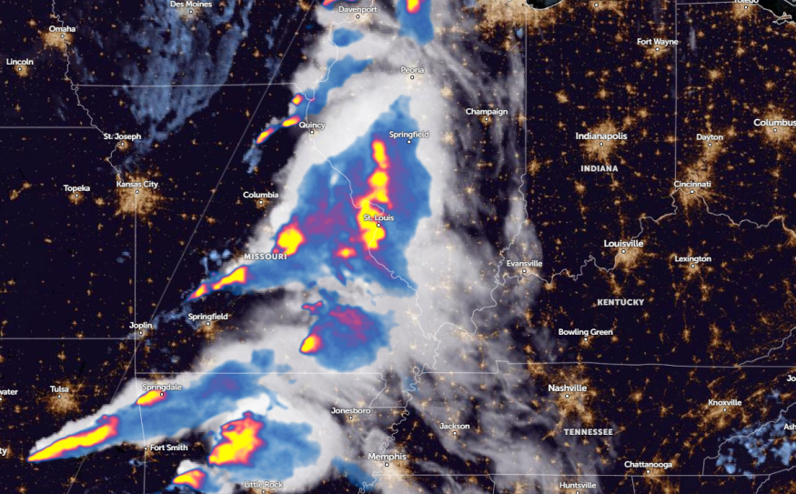
Missouri and Illinois can expect frequent lightning and tornado risks this week, according to a weather report by the National Weather Service (NWS) on May 21.
NWS monitors the development of a moderate risk of severe thunderstorms in the Middle Mississippi Valley and Upper Great Lakes. These thunderstorm threats can spread over Wednesday on the Southern Plains and Lower Mississippi Valley.
Additionally, travelers should be alerted to a slight risk of excessive rainfall in the Upper and Middle Mississippi Valley. Slippery roads and slower commutes are likely this week.
Missouri and Illinois weather outlook
The end week of May is expected to unleash severe thunderstorms packed with isolated tornadoes, hail, damaging winds, and flooding rainfall. The same weather risks can threaten southwest Wisconsin, northwestern Illinois, and northern Missouri.
A moderate risk of severe thunderstorms is issued in portions of the Upper and Middle Mississippi Valley, warning of frequent lightning, strong wind gusts, hail, and tornadoes. Damaging winds can damage small cars and houses, so it is best to limit outdoor plans when the weather becomes severe.
Furthermore, heavy rain potential can develop in northern Iowa, western Wisconsin, and Minnesota. The rain could be excessive, leading to flooded roads and flash floods. The combination of lightning and rain is life-threatening,
An NWS Weather Prediction Center report on May 21 warns of severe thunderstorm outbreaks in the Western Great Lakes and Midwest. The forecast monitors potential severe storms in eastern Nebraska and northern Missouri, including in the Northeast.
Travelers should stay alert for severe wind gusts reaching 75 mph, including very large hail. Meanwhile, isolated severe storms are likely in eastern Oklahoma, northwest Arkansas, and central Texas. Southeast Minnesota can anticipate a stormy outlook.
Next week, there is a threat of an early-season heatwave in Texas and Louisiana, with a chance of record or near-record temperatures. This weekend, the dangerous heat can occur in South Texas and the central Gulf Coast. While the weather is ideal for outdoor plans this Memorial Day weekend, prolonged exposure to hot weather can cause heat-related health concerns.
According to the report, residents can find relief from the challenging heat next week.
Read also: Memorial Day Weekend Weather: Severe Weather Likely to Unload from Arkansas to Mid-Atlantic
Staying safe from flooding downpours, hail, and tornadoes
The latest weather report raised concerns about the challenging weather outlook in the Northeast this week, with potential severe thunderstorms. Travelers should consider the weather outlook before traveling to avoid possible weather risks.
The likelihood of severe weather can become noticeable in the late week, particularly in Missouri and Illinois. Communities near streams and flood-prone areas should stay alert for flooding potential or the rapid rise of floodwaters.
Read also: Northeast I-95 Corridor Weather: Severe Thunderstorms Likely to Bring Challenging Commutes
For more similar stories, don't forget to follow Nature World News.
© 2026 NatureWorldNews.com All rights reserved. Do not reproduce without permission.


