The National Weather Service (NWS) reported that locally heavy rains and flooding can unload in the Florida Peninsula and Gulf Coast this midweek, bringing slower commutes for motorists.
While there won't be too much rain across the area today other than a few showers mainly in interior areas, rain chances are still forecast to increase over the next several days as a low pressure system in the Gulf of Mexico approaches the area. #FLwx pic.twitter.com/n7FPv9BT7O
— NWS Tampa Bay (@NWSTampaBay) November 13, 2023
In the recent NWN report, heavy rain conditions and strong winds were forecast in parts of the Gulf Coast, especially from Texas to Georgia. In the Northeast and Midwest, a warmer weather outlook is present until the rest of the week.
In this week's weather, the dangers are localized flooding, heavy rains and flash flood risks. Moderate to heavy rains can also cause slower commutes.
Locally Heavy Rains, Flooding: Where Will It Impact?
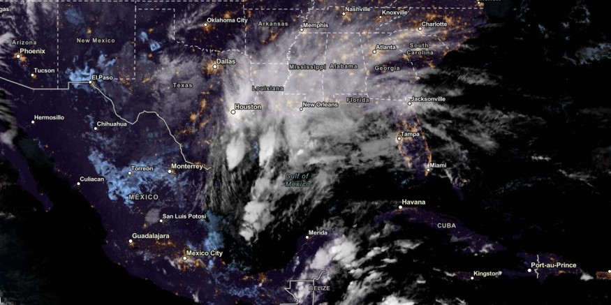
The NWS is monitoring an upper-level trough over the Southern Plains and a slow-moving low pressure in the Gulf Coast, bringing the much-needed rain to the region.
On Tuesday, the forecast showed that heavy rain conditions could unfold in the Central Gulf Coast. The rain will help low water levels and drought-affected areas in the Gulf Coast, especially the dry outlook over the Mississippi Valley.
Florida Peninsula can experience the brunt of heavy rains on Wednesday. The forecast warned of localized flooding in the region. In Tampa Bay, the latest advisory showed that rain could intensify in the coming days due to a low-pressure system. Jacksonville, Miami and New Orleans can also experience rounds of rain.
Meanwhile, a potential development could emerge over the Caribbean Sea this week. A possible late-season storm is possible as the Atlantic Hurricane finally ends this month.
Over the Central to Eastern US, NWS noted a high pressure in the region this midweek. The chance of rain is also low, including in the Great Plains. In the Northeast, residents can anticipate potential rain showers.
In addition, hotter to higher temperatures can emerge in the Central and Northern High Plains. Temperatures can increase from 10 to 25 degrees above average on Wednesday.
In the Intermountain West, warmer temperatures can dominate the region. While the colder weather is here, homeowners should avoid prolonged exposure to colder air.
Also Read : Late-Season Tropical Storm Likely to Emerge in the Caribbean Sea as Atlantic Hurricane Season Ends
Weather in Parts of the US: What Can Americans Anticipate?
In the latest advisory, a light snow accumulation can likely be in the Rocky Mountains and Northern Cascades this week. In California, a Pacific Storm can unleash rounds of rain and snow, including on the West Coast.
On Wednesday, the forecast revealed that a cooler outlook could unfold in New York City, Portland, Boston and Burlington. However, the warming trend is expected to return on Thursday.
Did you know? When thunder occurs, people are advised to seek for shelter or safe areas. Stay away from open areas or waters.
Related Article : Storm Over Gulf of Alaska to Bring Snow, Rain to West Coast This Week
For more similar stories, don't forget to follow Nature World News.
© 2026 NatureWorldNews.com All rights reserved. Do not reproduce without permission.


