After the process of rapid strengthening, weather experts said that Norma had intensified into a major hurricane.
Norma is seen to lose wind intensity, but it would still be a formidable hurricane as it slams into Mexico.
The weather system is also forecasted to unleash heavy rains in the central portion of the United States.
Norma's Track
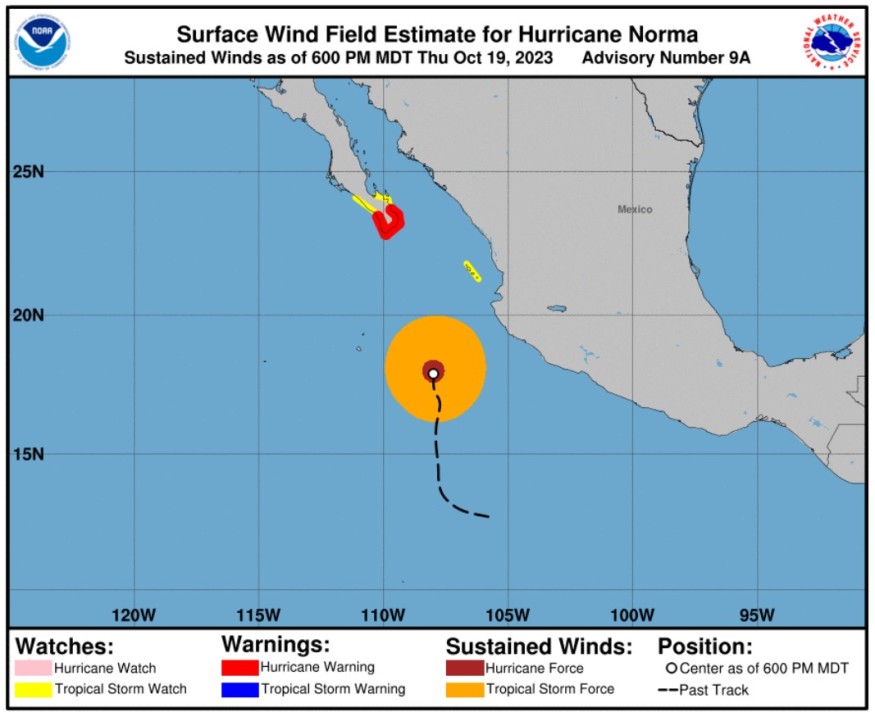
The National Hurricane Center said that at 300 PM MDT (2100 UTC), the center of Hurricane Norma was spotted near latitude 17.5 North, longitude 108.0 West.
Norma is moving towards the north near 6 mph (9 km/h). Further a turn to the north-northwest at a similar forward speed is expected during the next couple of days.
Meteorologists said that a slower northward to northeastward motion is forecast later this weekend.
They emphasized that based on the forecast track, Norma is forecasted to approach the southern portion of Baja California on Friday night and Saturday.
Weather experts said that maximum sustained winds are near 125 mph (205 km/h) with higher gusts.
They said that Norma is a category 3 hurricane on the Saffir-Simpson Hurricane Wind Scale. The Saffir-Simpson Hurricane Wind Scale (SSHWS) is a tool that meteorologists use to measure the intensity of hurricanes.
Similar to the Enhanced Fujita Scale used to measure tornadoes, the SSHWS divides hurricanes into categories based on the sustained wind speeds during the storm.
Under Category 3, devastating damage to homes and buildings are expected due to the expected sustained wind speed of 111 to 129 mph.
Meteorologists said that some weakening is expected during the next few days, but Norma is forecasted to be a hurricane when it moves near the southern portion of Baja California.
Norma's hurricane-force winds extend outward up to 35 miles (55 km) from the center and tropical-storm-force winds extend outward up to 150 miles (240 km).
The estimated minimum central pressure based on Air Force Reserve Hurricane Hunter dropsonde data is 944 mb (27.88 inches).
Hurricane conditions are expected within the warning area in Baja California Sur by early Saturday, with tropical storm conditions beginning late Friday night, according to the NHC.
Furthermore, tropical storm conditions are possible in Las Islas Marias Friday and Friday night, and in the watch areas in Baja California Sur on Saturday.
Norma is likely to produce rainfall totals of five to 10 inches with local maxima of 15 inches through Sunday across the far southern portion of California Baja Sur.
These rains will likely produce flash and urban floods, along with possible mudslides in areas of higher terrain.
The surf swells generated by Norma are affecting portions of the coast of southwestern Mexico and Baja California Sur. These will spread northward along the coast of western Mexico and the Baja California peninsula during the next couple of days.
These swells are likely to cause life-threatening surf and rip current conditions.
Meanwhile, some rains are also coming to some portions of the South Central states next week.
Any rains over the central states would be welcomed due to long-lasting and far-reaching drought conditions.
Read Also : Norma Takes Shape As Hurricane After Explosive Intensification, Landfall Expected In Mexico
Hurricane Warning
The government of Mexico has upgraded the hurricane watch for the southern portion of Baja California Sur from Todos Santos to Los Barriles to a hurricane warning.
Authorities have also raised a tropical storm watch from the north of Los Barriles to La Paz as well as in the north of Todos Santos to Santa Fe.
A hurricane warning means that hurricane conditions are expected somewhere within the warning area. It is typically issued 36 hours before the anticipated first occurrence of tropical-storm-force winds or the conditions that make outside preparations difficult or dangerous.
On the other hand, a tropical storm watch means that tropical storm conditions are possible within the watch area, generally within 48 hours.
Related Article : Tropical Storm Norma Could Transform Into Hurricane; Might Make Landfall Over Mexico
Related Video:
© 2026 NatureWorldNews.com All rights reserved. Do not reproduce without permission.


