Rain and isolated thunderstorms are expected to transpire in eastern and southern Australia until Friday, September 9, and Saturday, September 10, where it will gradually ease. This is according to the country's Bureau of Meteorology (BoM) which on Thursday, September 8, said the weather events will occur in parts of Queensland, New South Wales, and Victoria.
The BoM warns the thunderstorms will be severe, producing heavy rainfall and lead to flash flooding, as well as damaging winds and potential large hail. While there have been no immediate reports of significant disruption, a mild to moderate wet weather is possible in the said Australian states in the coming hours. Riverine flooding is possible for areas near bodies of water, including rivers and streams.
The Bureau attributes the weather phenomenon to an ongoing cold front associated with a low-pressure system over Australia. As a result, widespread rainfall between 15 and 30 millimeters is likely across inland New South Wales, northern Victoria, and southern Queensland. Rainfall accumulation could reach up to 50 mm., especially when under thunderstorms.
Similar phenomena have transpired during the winter season of Australia from June to August. As the country's spring approaches this September, the severe weather and torrential rain will apparently be the first during the current season. In early 2022, eastern Australia witnessed massive flash flooding due to heavy rain fueled by La Niña, resulting in large-scale evacuations and widespread disruption.
BoM Forecast
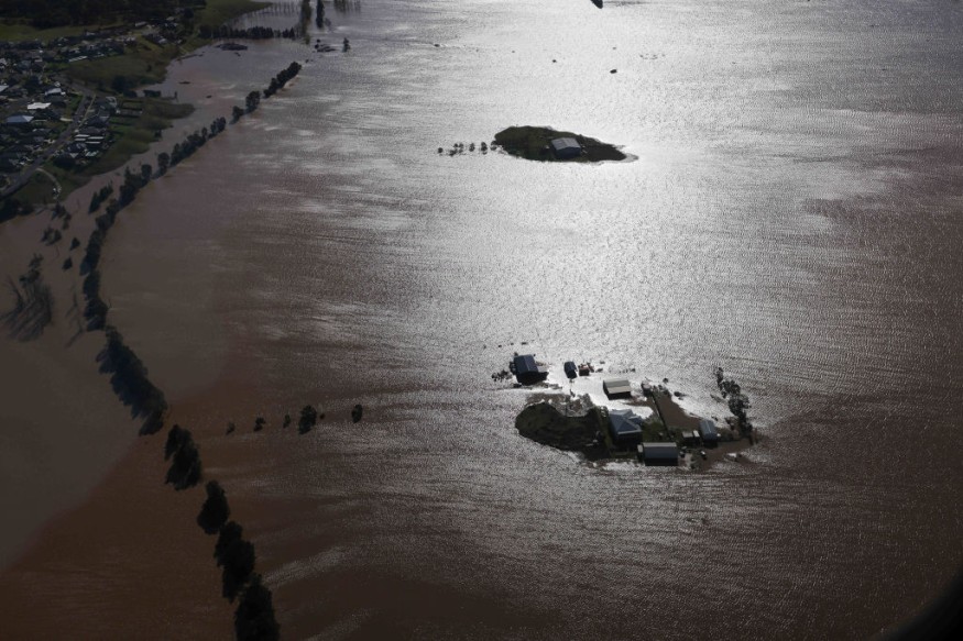
In its media release on Thursday, the BoM hinted it may issue severe thunderstorm warnings for parts of Queensland and New South Wales soon. In addition, the heavy downpour is also anticipated to cause renewed riverine flooding across many rivers already flooded in southern Queensland, New South Wales, and Victoria.
The authorities also said the cold front has already brought significant rainfall and giant hail in South Australia and western New South Wales overnight, with Port Augusta in South Australia experiencing the largest impact severe storms and flash flooding.
2,000 Kilometer Rain Band
Sky News Australia meteorologists on Wednesday, September 7, reported that a 2,000-kilometer rain band entered from Adelaide across to Queensland and New South Wales. They warned residents in Australia's east coast to brace for more wild weather and flooding as well.
The meteorologists urged residents to remain alert for local storm and flood warning. While capital cities will be reportedly spared, torrential rain in a short period of time could occur and add to water levels at the already-flooded catchments of the Murray-Darling basin, Sky News Australia adds.
Extended Winter
The ongoing weather system is expected to cause the heaviest low-level snowfalls of the year, as well as damaging winds and heavy rain, according to Nine News, which also cited BOM's forecast for Tasmania to receive a possible 300 meters of snowfall.
Meanwhile, the mainland can also receive as low as 500 meters of snow.
Australian meteorologists perceive the arrival of the winter chill indicates the winter is far from over.
© 2026 NatureWorldNews.com All rights reserved. Do not reproduce without permission.


