The Bureau of Meteorology (BOM) has issued a warning for more severe wet weather in NSW, including an east coast low bringing heavy rain and probable flash floods.
Emergency services have been swamped in parts of Sydney, including Hawkesbury-Nepean, Richmond, Menangle, and Windsor, and more severe flooding is expected.
New South Wales issued another evacuation alerts
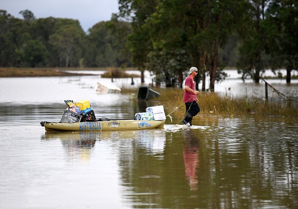
As a second east coast low approaches in as many weeks, New South Wales has issued eight evacuation alerts for its central coastal area, including sections of Sydney, with forecasts of further heavy rain and the risk for flash floods.
On Monday morning, the Bureau of Meteorology issued a severe weather warning, stating that six-hourly rainfall totals between 70 and 120 mm are probable.
According to ABC News, Jane Golding, a BOM meteorologist, stated that she knows east coast lows are dangerous weather systems, and while the storm hasn't formed into an east coast low yet, but as it does, they will be fine-tuning the warnings.
The Clarence River remains at a significant flood level in the state's north as people of the Northern Rivers clean up following last week's disastrous storms.
Golding said thunderstorms with huge hailstones, severe winds, and heavy rain might affect the Northern Rivers region, but they would be "hit and miss" rather than widespread.
There have been four confirmed deaths in the region so far, with other individuals remaining unaccounted for.
According to NSW Police Superintendent Scott Tanner, it is hard to provide a precise number since some persons may no longer be at their place of abode.
New South Wales issues evacuation warnings due to extreme flooding
According to The Guardian, the NSW State Emergency Service has issued evacuation notices for sections of the Hawkesbury-Nepean River, which is still flowing at high flood levels in North Richmond.
On Monday morning, the levels remained stable.
#Sydney’s Hawkesbury River region has many roads closed like this one: pic.twitter.com/r6AcIPqThP
— @phannam.bsky.social (@p_hannam) March 6, 2022
"We're encouraging everyone to be particularly cautious over the next three days," said Shellie Smyth, a spokesman with the SES. "If an East Coast Low forms over New South Wales, the main effect would most likely be on Tuesday."
On Sunday, dams in the Sydney area were 99.9% full, with the majority of them leaking. Warragamba Dam, the largest of them, has been leaking since Wednesday morning.
The spill rate reached 315 gigatonnes per day last week, up from 450 gigatonnes per day during the March 2021 floods.
Hundreds of volunteers from other states have arrived to help, and helicopters from the Australian Defence Force (ADF) and Rural Fire Services (RFS) are delivering vital supplies to towns.
Meanwhile, inhabitants in Huonbrook, inland from Brunswick Heads on the north coast, are still shut off owing to massive landslides.
There are network disruptions, as well as phone and internet service interruptions, increasing their isolation.
Locals and people in the neighboring areas are interacting with one another using two-way radios and checking in frequently.
On Monday, the emphasis will move to the Hunter and mid-north coast, where river levels remain high at Maitland, Singleton, Dungog, Gloucester, Wingham, and Taree.
Furthermore, Golding stated that on the plus side, the bad weather was expected to dissipate by Wednesday.
Carlene York, Commissioner of State Emergency Services (SES), said the priority had been to help individuals in Penrith, the Hawkesbury, and Mount Druitt, as well as to clear evacuation orders in the Northern Rivers.
© 2026 NatureWorldNews.com All rights reserved. Do not reproduce without permission.


