AccuWeather meteorologists say much of the eastern United States will experience a burst of spring-like warmth through Thursday night.
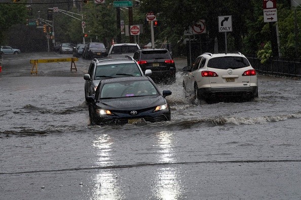
Potential Flooding Due to the Storm
According to AccuWeather, a powerful storm is expected to arrive and unleash soaking rain, melting snow, and a snow-eating wind, prompting rapid runoff and flooding from the lower Great Lakes to the interior Northeast that could last till Friday.
From Wednesday night to Thursday night, the same storm will bring heavy snow, a fast freeze, and even blizzard conditions to parts of the Midwest, as well as severe weather to the Mississippi Valley.
Winds from the south will increase as the storm moves across the central states, bringing warmer air to the eastern half of the country. Atlanta, Charlotte, Columbia, and Richmond, all in the South, will see highs of the 70s on Thursday.
Temperatures in New York City are expected to rise into the 60s this weekend. It is expected that temperatures in both Boston and Philadelphia would break daily record highs set in the 1980s and '70s, respectively. Temperatures could potentially reach 70 degrees in Washington, DC.
Increasing southerly winds may lower the temperature of the Atlantic Ocean and bays by several degrees and rapidly melt the snow that was left over from recent storms. This will reduce the risk of flooding.
AccuWeather Senior Meteorologist Adam Douty warned that by Thursday night, the winds can truly howl and get powerful enough to lead to occasional power outages and create flooding at periods of high tide.Warm air will also be pushed west and north of the Appalachiansm
A combination of warm air and gusty winds is expected to elevate the snowpack's temperature, which will set the stage for faster melting when rain moves in just before a blast of cooler air comes in from the north.
Places at Risk for Flooding
From the Tennessee and Ohio valleys southward to the southern St. Lawrence Valley, the storm scheduled to pass through the Central States is likely to drop 1-2 inches of rain, with isolated places receiving up to 2-4 inches.
This week's wet weather will likely lead to floods as a result of snow liquefaction and subsequent runoff into nearby streams and rivers. Flooding will be determined by the extent to which the glacier melts.
Cities like Indianapolis, Cleveland, and Akron, Ohio, may experience flooding. Pittsburgh and Erie, Pennsylvania, Buffalo, Syracuse, and Watertown, as well as Burlington and Montpelier, Vermont, will be at risk of flooding.
AccuWeather Senior Meteorologist Brett Anderson said, there is the potential for ice jams to form and add to flooding problems while potentially damaging property along the edges of streams and rivers in the interior Northeast and Midwest. According to Anderson, many of the waterways in this same region still have a substantial amount of ice on them.

Possible Temperature Swings
It's possible that Thursday will bring some flooding to the Midwest and sections of the Tennessee Valley, just south of the area where snowfall is expected.
In the eastern Great Lakes region, concerns will spread to the central and northern Appalachians on Thursday night, which includes places with greater snow accumulation.
Although there was some flooding in the area, it was mostly minor or limited because of the quickness with which it thawed and stopped raining. However, catastrophic flooding may be unavoidable in some areas of tiny streams and rivers.
It is possible that the high pressure system that is currently positioned over the southern Atlantic coast may remain in place for some time, which would allow a cold front moving east toward the mid-Atlantic and southern New England to reduce rainfall.
Accompanied by thunderstorms and lightning, torrential rainfall may prompt flash flooding and travel delays in the central and southern Appalachians Thursday night into the early morning hours of Friday morning in the Interstate 95 corridor. Some communities may lose electricity if trees fell and block streets and secondary roads due to the severe winds expected Thursday night and early Friday.
In a typical case of weather whiplash, Rayno predicted that temperatures would plummet from west to east from Thursday night into Friday morning almost as swiftly as they rose over the region on Thursday afternoon.
Related Article : Unpredictable Weather May Lead to Flash Flooding and Rain Hazards
For more news, updates about flooding and similar topics don't forget to followc Nature World News!
© 2026 NatureWorldNews.com All rights reserved. Do not reproduce without permission.


