As the Upper Midwest and Northeast are blanketed in arctic air, several Gulf Coast regions faces risk of more tornadoes.
Officials Issued Wind Chill Advisories
According to experts, a wind chills of -25 to -40 degrees are anticipated to hit 10 million people in regions of North Dakota, Minnesota, and Wisconsin on Monday.
Wind chill advisories have been issued for parts of New York, Vermont, and Massachusetts through Tuesday, with wind chills anticipated to fall to 35 degrees below zero, according to News Channel.
Frostbite can occur in as little as ten minutes under these dangerously cold wind chills, according to the National Weather Service.
By Monday and Tuesday, the Northeast is expected to feel the effects of this record-breaking cold. Northeast and New England interiors may see lows of 0 degrees on Tuesday morning.
In the area between Lake Superior and Lake Ontario, the bitter cold and howling winds will produce significant amounts of lake effect snow.
According to the Weather Prediction Center of the National Weather Service, a foot of snow is expected to fall in sections of Michigan's Upper Peninsula and the Tug Hill Plateau of New York by Tuesday morning.
Also Read : Tower in Texas that Survived Strong Tornado, Now Being Turned into Residential Apartments
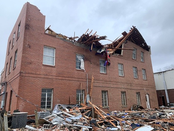
Tornado Impacted Rural Alabama
There are severe weather advisories out on Sunday for more than 10 million people throughout the Gulf Coast, from eastern Texas to Florida's panhandle.
According to the NWS, there was at least one verified tornado in southern Alabama on Sunday afternoon, near McKenzie.
Parts of Mississippi and Alabama were under a tornado warning through Sunday evening at 6 p.m. (7 p.m. ET).
According to the Storm Prediction Center of the National Weather Service, an isolated large hail storm is possible today across parts of Louisiana (including New Orleans), Mississippi (including Jackson), and Alabama (including Birmingham).
There was a level 2 out of 5 risk for severe storms in Mississippi and Alabama as of Sunday afternoon.
Flooding is also a possibility along the Gulf Coast due to the 2 to 3 inches of rain forecast in certain spots.

Residents Urged to Avoid Driving
Throughout areas of Pennsylvania and New York, freezing rain and sleet have descended on the region. In other parts of the region, heavy snowfalls are wreaking havoc.
The National Weather Service at State College, Pennsylvania, warned of "significant icing" for sections of central Pennsylvania in its forecast.
It is likely to accumulate a quarter to half inch of ice on Sunday, according to the forecast.
There are perilous driving conditions. Untreated surfaces will be exceedingly slippery. Power disruptions are possible, according to the National Weather Service (NWS).
Residents and citizens are warned to avoid driving unless absolutely necessary.
"If you must travel, keep an extra flashlight, food and water in your vehicle in case of an emergency," the NWS office in State College said.
Wide portions of New England were forecast to get anywhere between a glaze to a quarter inch of ice Sunday. But most of the ice accumulations are anticipated to stay west of the big urban centers.
Related Article : EF1 Tornado Devastated Southern Florida, Leaving Wreckage Behind
For more news, updates about tornadoes and similar topics don't forget to follow Nature World News!
© 2026 NatureWorldNews.com All rights reserved. Do not reproduce without permission.


