Intense storms ripped over Southwest Florida, bringin in a tornado, leaving a trail of destruction and causing numerous counties to issue tornado watches.
Tornado Watch
On Tuesday morning, a tornado watch was issued for the whole southern Florida area. It was valid till 10 a.m. EST.
After predicting a "moderate" possibility of two or more tornadoes occurring in the area, the National Oceanic and Atmospheric Administration issued the warning.
At 6:25 a.m., a tornado touched down near south Fort Myers, according to the National Weather Service. Its strength and rating are still up in the air.
Kissimmee, Sarasota, Miami, Fort Myers, and West Palm Beach were hit.
The NOAA warning stated, "Remember, a tornado watch implies conditions are favorable for tornadoes and strong thunderstorms in and around the watch region." "People in these places should keep an eye out for dangerous weather and listen for later remarks and possible warnings."
Related Article : Study Shows How Global Warming Creates More Powerful Winter Tornadoes
Wrecking the Region
In several sections of the impacted region, trees have fallen, destroying automobiles and impeding roadways.
According to Florida Public Radio's Emergency Network, a 73 mph (117 kmh) wind was recorded in Manatee County.
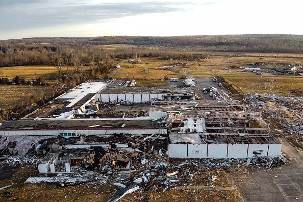
The storm slammed Florida only 11 days after powerful tornadoes blasted through Kentucky, killing at least 76 people and destroying more than 1,000 homes.
Since the 11th, relief workers in the state have been caring for survivors, searching for the missing, and clearing wreckage in the impacted areas.
Tornado Activity
Several tornadoes were verified to have struck during the storm. However, according to the National Weather Service, the precise number is still unknown.
The tornado that struck Mayfield, Kentucky, was classified as an EF4, the storm's second-worst category. According to the National Weather Service, ratings are based on projected wind speeds and their damage.
More than 100 persons were reported missing following the storms, and tens of thousands of people were left without electricity. However, most of the power has since been restored.
While storms such as tornadoes and hurricanes are more difficult to link to climate change than other occurrences such as droughts or cold spells, climatic data suggests that warming induced by carbon emissions into the atmosphere contributes to storms being more intense, if not more frequent.
"Climate model estimates for the United States imply that by the end of the twenty-first century, the overall chance of favorable ingredients for severe storms would grow," stated John Allen, an atmospheric scientist at Central Michigan University, in SciTech Daily. "The major explanation is that increased moisture in the atmosphere, along with rising temperatures, enhances the possibility for severe updrafts."
Intensified by Global Warming
He claims that global warming increases the risk of powerful storms occurring at periods when there were previously few such occurrences.
"Rising global temperatures are causing big changes for seasons that we used to assume only produced catastrophic weather seldom," he added. "In the autumn, winter, and early spring, higher increases in warm, humid air imply more days with ideal severe thunderstorm conditions - and when these storms do occur, they have the potential to be more intense."
For more news about the environment , don't forget to follow Nature World News!
© 2026 NatureWorldNews.com All rights reserved. Do not reproduce without permission.


