As a violent storm raged through sections of California and the Pacific Northwest Sunday night, evacuations were ordered, highways were closed, and hundreds of thousands of people were without power.

The weather presented the prospect of landslides and flooding, both of which might be fatal.
The risk is incredibly high on wildfire-ravaged terrain, subject to floods and a particularly catastrophic and fast-moving form of landslide known as "debris flows."
Declaring Watches and Advisories
Flooding and debris flow watches and advisories were issued ahead of the storm for regions such as the Dixie and Alisal burn scars.
The weather is providing respite from a severe drought and reducing the threat of wildfires this autumn. However, how the region's wet season will play out remains to be seen.
Here's a look at what happened on Sunday during the day and evening.
According to poweroutage.us, about 400,000 power outages were recorded across three states. In addition, over 179,000 people were in Washington, many of them being displaced by severe winds in King County, near Seattle.
In California, around 175,000 homes and businesses were without power. Northern coastal counties such as Sonoma, Marin, and San Mateo saw the most outages. Others were centered in the counties of Butte and Nevada.
Related Article : Incoming Storm Trio Labeled the 'Cyclone Bomb' May Help Combat Wildfires in the West
Forcing Residents to Flee
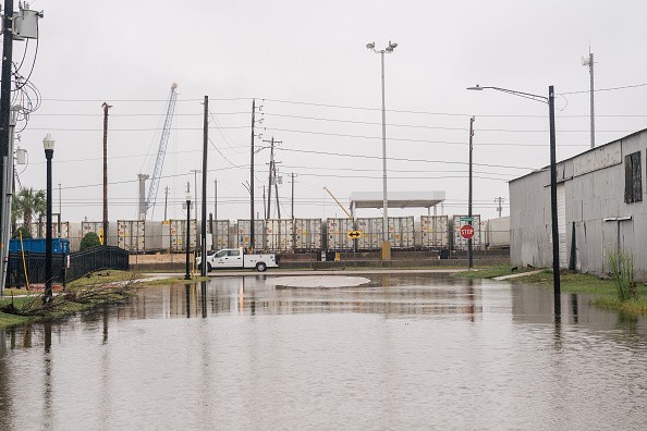
Flooding forced residents in one Santa Rosa neighborhood to flee. According to the San Francisco Chronicle, firefighters went door to door in water rescue gear and evacuated an apartment complex.
San Rafael police sent a notice to residents on Sunday afternoon, warning of severe flooding in the city's downtown area.
The notice stated that "several highways are under 2 feet of water and are inaccessible or otherwise blocked." "Another high tide is expected to exacerbate the flooding, in addition to the rainfall levels from the 'atmospheric river.'"
The city is located north of San Francisco on the bay.
Burn Scarred Areas Under Watch
Residents in the Fresno County part of the Creek Fire burn scar were also advised to leave. their residences
According to the county sheriff's department, the impacted region includes Big Creek Canyon from below Big Creek to the San Joaquin River.
In the year 2020, the Creek Fire raged in Fresno and Madera Counties.
Landslides
Several landslides occurred, one of which closed Highway 70 near Tobin in Plumas County, where the Dixie Fire had left vast swathes of burn scars.
The National Weather Service in Reno tweeted, "Numerous mud, rock, and debris flows have been recorded." "This event is only getting started! Today, keep cautious and safe!"
Downed Power Lines
Throughout the city, there were multiple cases of downed power lines and trees obstructing highways.
San Mateo County firefighters responded to scores of storm-related calls, including downed trees and electrical lines, south of San Francisco.
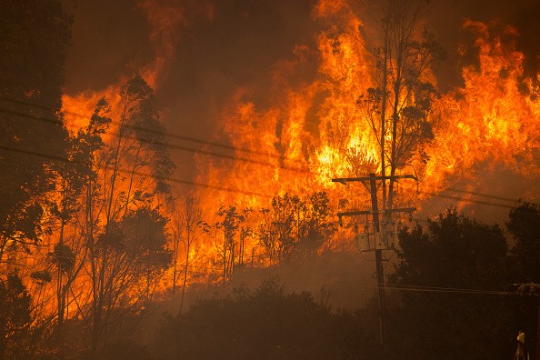
Some people in the Alisal Fire burn scar region, including locations west of Las Flores Canyon, east of Mariposa Reina, south of West Camino Cielo, and down to the seashore, have been told to evacuate. On Saturday, a warning was issued, which was later increased.
This month, the Alisal Fire broke out in Santa Barbara County, consuming more than 26 square miles.
What Happened?
Debris flows were already happening Sunday morning, according to the National Weather Service in Sacramento. The government issued an alert warning resident that time may have run out for some to depart.
"It may be too late to leave if you are near a burn scar," the agency stated in a tweet. "Crossing a debris flow is not a good idea. Instead, take refuge on the top level of your house."
Rushing water and muck, as well as strange sounds like cracking, breaking, roaring, or the sound of a freight train, are all warning indicators of an imminent debris flow.
The rain results from a powerful storm that came into California on Sunday, tapping into a strong atmospheric river.
This newest storm to strike the West Coast is dumping soaking rain from Northern California to the Pacific Northwest.
In certain regions, heavy snowfall is also likely.
Debris Flows
Wildfire-ravaged terrain is especially prone to "debris flows," a particularly deadly and fast-moving form of landslide. Short, intense rainstorms can cause mudslides, sending a wall of water, earth, ash, plants, boulders, and other debris careening downward, wiping away or burying everything in its path.
In an interview with weather.com, Jason Kean, a debris flow expert with the US Geological Survey, said, "A debris flow is a kind of like a flood on steroids." "It's all piled high with rocks, dirt, and boulders - some of which are the size of vehicles."
Wildfires disrupt the nature of the soil itself, in addition to eliminating plants that would ordinarily hold soil and debris in place. As a result, it becomes less prone to absorb water, allowing flash floods and debris flows.
For more news about making the environment sustainable, don't forget to follow Nature World News!
© 2026 NatureWorldNews.com All rights reserved. Do not reproduce without permission.


