Divers at the scene of a continuing oil leak in the Gulf of Mexico during Hurricane Ida have identified the likely source as a one-foot diameter pipeline that was moved and ripped free from a trench on the ocean floor.

In a statement released Sunday evening, the Houston-based business Talos Energy, which is paying for the cleanup, stated that the burst pipeline is not theirs.
The firm said it coordinates the response with the US Coast Guard and other state and federal authorities to determine who owns the damaged pipeline.
Investigating Pipelines
Two other 4-inch pipelines have been discovered in the region, both open and appear to be abandoned. Although the company's statement did not specify whether oil was leaking from the two smaller pipelines, satellite images reviewed by The Associated Press on Saturday appeared to show at least three different slicks in the same area, the largest of which was drifting more than a dozen miles (more than 19 kilometers) eastward along the Gulf coast.
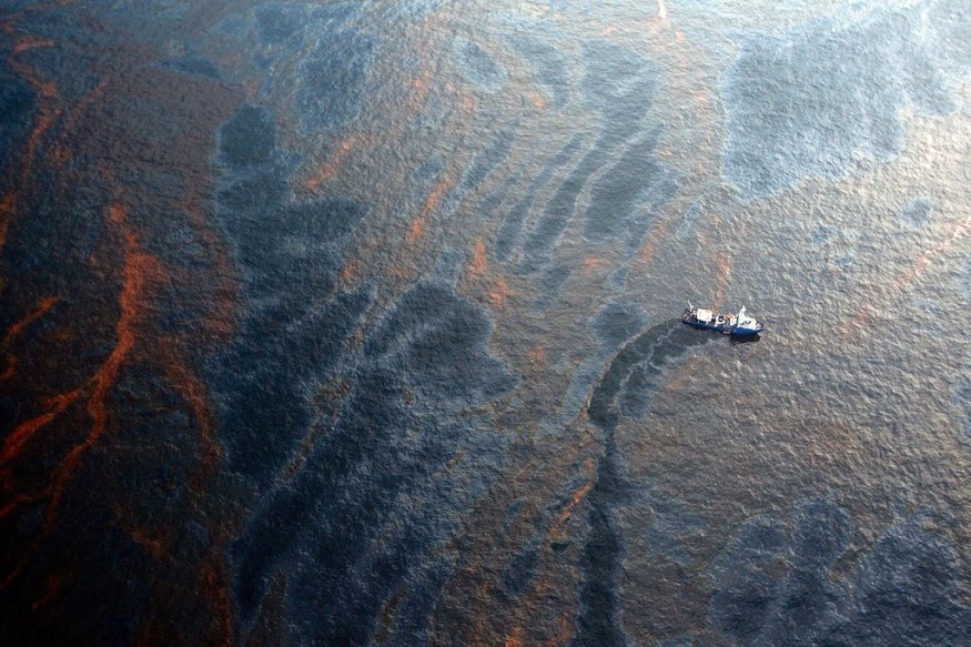
Aerial pictures released by the Associated Press on Wednesday showed a miles-long brown and black oil slick extending approximately 2 miles south of Port Fourchon, Louisiana. At around 34 feet deep, the damaged pipe is in comparatively shallow water.
Oil Reaching the Surface
According to Talos, the rate of oil coming to the surface has dropped considerably in the previous 48 hours, and no new heavy black crude has been observed in the last day.
The leak appears to have stayed out to sea so far, with minor damage on the Louisiana coastline. However, the amount of oil in the water has yet to be determined.
Related Article : Oil Spill the Size of New York City Poses Risk to Marine Life in Mediterranean Sea
Monitoring the Situation
The Coast Guard stated Saturday that its reaction teams are monitoring reports and satellite images to assess the extent of the discharge located in Block 4 of Bay Marchand. According to Talos, the firm formerly leased Bay Marchand, Block 5, but stopped producing there in 2017, capped its wells, and destroyed all pipeline equipment by 2019.
Oil and Gas Drilling
For decades, the region where the leak occurred had been drilled for oil and gas. As a result, it comprises a latticework of ancient pipelines, plugged wells, abandoned platforms, and modern infrastructure that is currently in operation, according to federal leasing maps.
Cleaning the Spill
Talos hired Clean Gulf Associates to respond to the leak because the source of the oil was unknown. Since Wednesday, two 95-foot vessels from Clean Gulf, a nonprofit oil-spill response cooperative that works with the energy exploration and production industry, have been at the spill site working to contain and retrieve petroleum from the sea.
Environmental Risks After the Storm
Following the Category 4 storm that made landfall at Port Fourchon a week ago, state and federal officials track hundreds of reported environmental risks in Louisiana and the Gulf. The area is a significant petrochemical production hub in the United States.
The Associated Press was also the first to publish pictures from the National Oceanic and Atmospheric Survey that showed severe flooding and what looked to be petroleum in the water at the massive Phillips 66 Alliance Refinery south of New Orleans.
Immediate Response
Following the publication of the pictures by the Associated Press, the Environmental Protection Agency dispatched a specially equipped survey plane to fly over the refinery on Thursday, as well as other industrial facilities in the hurricane's path of 150 mph winds and storm surge.
According to the Louisiana Department of Environmental Quality, a state assessment team deployed to the Alliance Refinery saw a significant oil leak being dealt with booms and absorbent pads. In addition, a levee designed to safeguard the facility had broken, enabling floodwaters to pour in during the storm and escape when the surge subsided.
Assessing the Situation
According to state environmental officials, there was no estimate yet available for how much oil may have leaked from the Phillips 66 facility.
Read also: Marine Bacteria Found Capable of Biodegrading Diesel and Oil: Can it Clean Up Oil Spills?
For similar news, don't forget to follow Nature World News!
© 2026 NatureWorldNews.com All rights reserved. Do not reproduce without permission.


