The steamy air over the Northeast will be of great help in getting the stage ready for rounds of intense to severe thunderstorms to erupt daily through the weekend, said AccuWeather meteorologists.

High Temperature
Anybody going outside across the area may be thinking they've been carried to Florida because of the high humidity levels that have made the area feel very hot.
For most of the area, high temperatures through the remaining part of the week will stay in the 90s F, with AccuWeather RealFeel® Temperatures some degrees above the usual thermometer reading.
AccuWeather RealFeel® Temperatures will attain the highest point with 100- to 105-degree range every afternoon along the Interstate 95 corridor from Washington, D.C., to New York City. The hot and steamy air will get the stage ready for more than the usual ordinary type of thunderstorms that can blossom during the season of summer.
Alex DaSilva, an AccuWeather Meteorologist said: "The Northeast will be stuck in a very active weather pattern through the rest of the week as several disturbances sweep through the region."
As these disruptions merge with the sticky air, thunderstorms will be triggered and could become powerful.
Also Read: Dangerous 'Omega Block' Heat Dome is Looming Over US and Canada, Causing Severe Heat
Thunderstorm Prompts Power Outage
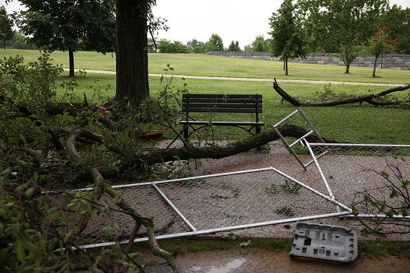
DaSilva said while a lot of storms will cause heavy downpours, there is a possibility that few storms will become severe and cause localized damaging winds.
As storms continue with great force across the Northeast on Tuesday, the Storm Prediction Center of the National Weather Service listed various preliminary wind reports across eastern Pennsylvania, Virginia, and Maryland. It was reported that the wind has fallen several trees and power lines.
On Tuesday, at about 7 p.m. PowerOutage.US had listed more than 85,000 consumers with no power across Virginia as storms invited powerful winds gusted through the affected counties of the state. The number of power interruptions began to fall not too long after as crews made effort to restore power.
Power interruptions weren't the only hazard that came from the storms. Officials in Germantown, Maryland, are holding the lightning strike accountable for a two-alarm fire at an apartment complex.
Wildfire
Just after 5 p.m. EDT, the fire started at a 3-story apartment complex on Millhaven Place. The fire displaced dozens of inhabitants from 12 condos and brought about remarkable damage to the building, as per a tweet from Pete Piringer, Montgomery County Fire and Rescue spokesman.
Earlier, several people had been wounded and several pets had been saved, the spokesman noted.
Footages and pictures of the fire reveal a partial structure collapse, and all lanes of Great Seneca Highway were shut down from Mateny Road to Dairymaid Drive as firefighters made efforts to extinguish the raging fire.
Not a day is anticipated to be a total washout, but those that made plans to go outside will surely want to focus on weather apps to have knowledge about a breakdown of hourly and minute precipitation forecasts for their area.
For more news, updates about thundersorms and similar topics don't forget to follow Nature World News!
© 2026 NatureWorldNews.com All rights reserved. Do not reproduce without permission.


