Meteorologists at AccuWeather have some good news for a region of the country dealing with seemingly endless downpours and flooding issues since May. A shift in the weather pattern will bring drier weather to Texas and Louisiana throughout the week as downpours move further north and east.
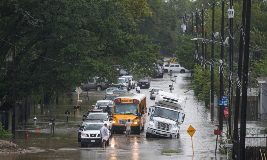
Since May 1, rainfall has been estimated in feet from Victoria to McAllen, Texas, and into southern Louisiana, including Lake Charles. The remarkable totals were aided by a sluggish weather pattern that drew tropical moisture from the Gulf of Mexico. During this season, these places receive half a foot of rain or less on average.
Early June Rain
During the early days of June, a slow-moving storm in the upper atmosphere brought further rain to these locations.
Houston received over 5 inches of rain in only two days on June 2-3, more than the city usually receives in a month. Victoria had 5.05 inches of rain from June 1 to 5, above the month's normal of 4.46 inches.
Frequency of Heavy Rains

Thankfully, because the significant rain fell over several days rather than all at once, there have been few new flood incidences in recent days. Nonetheless, analysts warn that residents and visitors should not relax their vigilance just yet.
Early this month, the slow-moving upper-level storm will likely continue to produce scattered showers and stronger thunderstorms throughout parts of northern and eastern Texas and Louisiana daily.
"Due to how extraordinarily wet it has been," Meteorologist Isaac Longley said, "heavier downpours that come will still carry the potential of flash flooding."
Flooding
It's likely that one or more thunderstorm complexes rumble over Texas late Sunday and then again late Monday, possibly in the Red River Valley, causing severe weather. If these storm complexes develop, the most dangerous threats are expected to be damaging winds and hail.
The downpours, according to forecasters, will not be limited to these states. In fact, by the middle of the week, the more concentrated regions of heavy rainfall throughout the lower Mississippi, Tennessee, and Ohio valleys are projected to migrate farther north and east.
On Sunday, widespread downpours began to hit Arkansas, Mississippi, Alabama, and Tennessee, resulting in a drenched weekend.
Following the sporadic downpours, the pattern will give a breather for the hardest-hit parts of Texas and Louisiana as the stormy weather zone travels farther north and east as the week unfolds.
According to Longley, an area of high pressure will form over northern Mexico and spread into the southern Plains by midweek, suppressing most thunderstorm activity through the end of the week and into next weekend.
Dryer Weathers Incoming
Dryer days will allow still-swollen rivers to ebb, as well as provide more possibilities for folks to get outside and perform yard work, exercise, or visit the beach.
According to AccuWeather's long-range forecasting team, this dry pattern might last until the middle of June. After that, the Ohio Valley to the mid-Atlantic and Southeast coast is likely to become the more active corridor for frequent storms.
For more climate and weather updates, don't forget to follow Nature World News!
© 2026 NatureWorldNews.com All rights reserved. Do not reproduce without permission.


