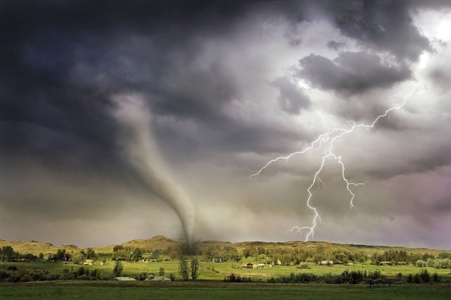
On Monday evening, a massive and highly dangerous tornado struck near Selden, Kansas, injuring one person and causing extensive damage. Around 6:30 p.m., the twister hit. CDT, according to Sheridan County Emergency Management. Buildings, houses, silo, trees, semi-truck, and trains were all destroyed.

As it charged into northwestern Kansas, an extreme storm that had a history of stirring up tornadoes spawned the dangerous weather.
According to AccuWeather Senior Meteorologist Dave Bowers, the thunderstorm first developed southwest of Goodland, Kansas, around 3 p.m. CDT. It then tracked northeastward ahead of a frontal boundary, where it repeatedly dropped tornadoes for a few minutes at a time over the next few hours.
"This one supercell produced nearly a dozen tornado reports." Tree and power line disruption, as well as one injury, were reported at 6:26 p.m. CDT at Selden," Bowers said.
Related Article : For Millions of People, Memorial Day Weekend Could be Ruined by Bad Incoming Storm
Caught by Storm Chasers
Scott Peake, a storm chaser, had a good look at the tornado that hit Selden, Kansas. As Peake approached in a car, he caught video of the tornado rising and swirling. A huge sheet of metal can be seen floating over the road in front of him, courtesy of the twister.
CONVEX, a group of tornado chasers that captures data from within and around tornadoes, collected video from afar after an intercept probe was lowered into the storm's path. Crew members can be heard shouting, "Oh, no!" As the video progresses, they exclaim, "Oh my God!" and "It's reaching the area!" before scrambling to get farther away.
No Injuries
There were no major injuries recorded, but plenty of collateral damage, according to KSNW, the local NBC station. According to KSNW, the local sheriff reported that 38 properties received major damage, while 84 others received moderate damage.
"This town will be rebuilt," says the narrator. "According to KSNW, Sheridan County Fire Training Chief Steve Hirsch said. "Because of the people who live here, it would be just as powerful as it was before. They've survived droughts, and they've survived tornadoes, and they're going to survive this tornado," Hirsch said.
Spotty Heavy Storms
According to Meteorologist Mary Gilbert, rounds of spotty heavy storms will begin to rumble through parts of the Plains each day until at least Tuesday night.
Severe weather threats would largely change their attention away from Colorado and toward the east.
Downpours and violent storms are expected to form in a similar region from the southern Plains to parts of the upper Mississippi Valley on Tuesday afternoon and night.
Depending on how much cloud cover and rain remains from Monday night, there could be a significantly lower chance of extreme weather today. Regardless, storms may generate hail and destructive wind gusts, as well as torrential downpours, according to forecasters.
For more climate and weather updates, don't forget to follow Nature World News!
© 2026 NatureWorldNews.com All rights reserved. Do not reproduce without permission.


