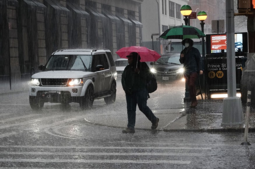
A line of heavy thunderstorms prompted extreme weather warnings for most of the tri-state region on Wednesday afternoon.
The major threats tend to be damaging storms, downpours, and widespread lightning; hail was recorded in Brooklyn and Manhattan, and a brief tornado warning was given for Dutchess County.
Temperatures will drop after the storms pass through, only reaching 50 degrees on Thursday; wind gusts of 40 mph or higher will make it sound like the 20s and 30s for most of the day.
Related Article : Powerful Late Winter Snow Storm Hurls Towards the Western US
Storms in NY and NJ
Sound up to hear the hail pinging off a building in Tribeca. #NYwx #NYC https://t.co/n9aDQkg3rJ
— Storm Team 4 NY (@StormTeam4NY) April 21, 2021
Strong storms rumbled through most of New York, New Jersey, and portions of Connecticut on Wednesday afternoon, pelting the region with hail and threatening the tri-state with damaging winds, heavy rain, and lightning.
Brief Tornado Warning
WILD WEATHER: This rotating thunderstorm was the tornado warned storm passing from Dutchess County, NY into Litchfield County, CT earlier this afternoon.
— News 12 Weather (@News12Weather) April 21, 2021
Send us your storm photos and videos: https://t.co/8vx5mCXcdz
📷: @wflamholtzwx pic.twitter.com/JGoU4FnoRC
As the storms hit, pea-sized hail was recorded in Brooklyn, while larger hail was seen in Manhattan. When the strongest storms struck, a tornado warning was released for Dutchess County, but it was lifted shortly after 3 p.m. For the most up-to-date information on the storm's timing and predicted effects, check out the live radar here.
Intense Storm

Severe thunderstorm warnings had been released by mid-afternoon for nearly the entire tri-state south, as wild winds toppled trees in Ulster County and elsewhere. More possible pop-up storms should be expected until about 6 p.m. when the worst weather should start to shift out of the city.
Long Island is also under a severe thunderstorm warning until 4:45 p.m. Here you will find the most recent extreme weather warnings for your region.
The extreme weather risk in and around the city was elevated Wednesday morning ahead of the storms, with most locations in and around the city in the "more likely" category. They began moving in shortly after lunchtime and will continue to do so until about 6 p.m. in various areas of the tri-state region. When the National Weather Service released the slew of alerts, the region was forecast to see the worst weather at 3 p.m.
Duration
Storms that may have lingered are forecast to dissipate by Wednesday evening when gusty winds and much cooler temperatures arrive. The high for Wednesday is forecast to be about 64 degrees. After that, temperatures are expected to plummet.
Temperature Drop
The entire area will experience a significant drop in temperature overnight, with a high of just 51 degrees forecast on Thursday. For most of the day, strong winds gusting above 40 mph will make it sound like it's in the 20s and 30s.
A freeze alert has been released for parts of the area from late Wednesday through Thursday morning, with lows forecast to be close or below zero. Here you will find all of the most recent extreme weather warnings for your region.
For more weather news, don't forget to Follow Nature World News!
© 2026 NatureWorldNews.com All rights reserved. Do not reproduce without permission.


