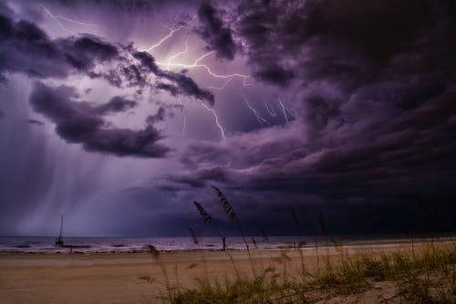
It is now the season for Derechos in the US, and we should be prepared for these destructive thunderstorms. About 10% of storms in the country turn into severe weather events, which produce one-inch (or 2.5-centimeter) diameter hails or larger; violent tornadoes; and over 50 knots (or 57.5 miles per hour [mph]) of severe winds. The fast-moving, large thunderstorm complexes characterized by straight and powerful winds are known as Derechos.
Derechos mainly occur in the eastern and central parts of the country, with an average of one or two occurrences per year in most locations. They cause significant damage. A derecho last June 3 in New Jersey and Pennsylvania caused the deaths of four people with power outage all across the area of the mid-Atlantic.
The western region experiences fewer Derechos. However, Colorado had a powerful and rare one on June 6, which had winds above a hundred miles per hour in many areas. Derechos also occur in Asia, South America, and Europe.
Scientists recognize that thunderstorms with organized lines cause widespread damage. University of Iowa professor Gustave Hinrichs analyzed the severe winds that occurred from the 1870s to the 1880s, observing that straight-line winds produce more destructive storms than the rotating winds of tornadoes. Hinrichs coined the term "derecho," which in Spanish means "straight" for the destructive windstorms that are not caused by tornadoes.
Meteorologists classify a storm system to be a derecho when it produces winds equal to or greater than 57.5 mph (or 26 meters per second). In addition, these winds must cover a minimum path of 400 kilometers or 250 miles long within three hours of individual wind reports.
Almost always, Derechos are caused by bow echoes, weather systems that are bow-shaped when they appear on radar. Bow echoes are a kind of mesoscale convective system, or a type of organized, large storm groupings.
Some characteristics of mesoscale convective systems may be affected by climate change, although it is not yet clear how global warming will affect the severity and frequency of Derechos.
Derechos can be a challenge for meteorologists to predict. When they occur, it is usually uncertain if a storm will even occur at all. However, when they do, there is a good chance that an explosion of severe winds will develop. For instance, meteorologists were not able to predict the calamitous derecho, which occurred in June 2012 until the derecho was already well on its way.
Another example was the June 6, 2020 derecho. At that time, the outlook did show a good chance for a severe storm in the areas of North and South Dakota and Nebraska two or three days prior to the event. Unfortunately, the forecast did not anticipate the possibility of destructive winds going south to Colorado; it was only on that very morning that the formation of a derecho was experienced.
Upon the development of a line of storms, it is routine for the National Weather Service to issue very accurate warnings for thunderstorms a half hour to an hour before severe winds arrive. Utility workers, responders, and communities sometimes only have several hours before they are warned of a coming storm. So everyone is advised to be able to quickly receive warnings of coming natural disasters, take them seriously, and be prepared for them at any time. Derechos can be destructive and should not be taken lightly.
© 2026 NatureWorldNews.com All rights reserved. Do not reproduce without permission.


