South-Central US can expect a wetter weather outlook this week due to potential heavy rains. Potential flash flood risks and flooding are likely, causing slower commutes and hazardous travel. People with travel plans should stay updated with the latest weather forecast, including checking for road conditions.
The NWS Southern Region reports that a potential severe weather threat can return to the region. A Slight Risk for severe thunderstorms can unload in portions of Texas, Arkansas, Oklahoma, and Tennessee.
The advisory warns of potential severe thunderstorm concerns in the early weeks.
An enhanced risk for severe weather can bring severe hail and tornadoes from parts of Iowa into northern Missouri, including west-central Illinois.
In Chicago, the weather report also warned of severe weather threats, particularly in areas in Winnebago, Lee, and Ogle counties. Homeowners should watch out for damaging winds and challenging hail conditions.
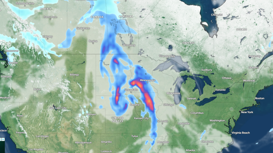
Weather in the South-Central US This Week
The NWS Weather Prediction Center reports that scattered thunderstorms are likely in southwest Wisconsin and Illinois. Limiting unnecessary travel is recommended to keep safe from flooding concerns and severe weather threats.
Meanwhile, the latest weather advisory warns of soggy weather conditions and thunderstorm threats in the south-central US. People in low-lying communities are vulnerable to flooding risks, and motorists can likely face difficulties in their commutes due to the weather. The chance of rain is expected to last until the weekend.
Homeowners are advised to take precautions for potentially isolated tornadoes, particularly during the night. Staying updated with mobile alerts is recommended. On Thursday, the stormy conditions are likely in the following:
- Omaha
- St. Louis
- Indianapolis
- Chicago
- Saginaw
- Little Rock
- Dallas
- Omaha
On Saturday, the significant rainfall can bring potential flash flood risk and locally severe thunderstorms, causing potential travel delays. Frequent downpours can unload in the following areas:
- Little Rock
- Dallas
- Abilene
- Austin
- Houston
- Alexandria
The heaviest rain will likely come from New Orleans and Tallahassee, including on Interstate 10 and Interstate 20. Portions of northeastern Texas to northern Louisiana, including Mississippi, can also experience the same rounds of rain.
In Little Rock, showers and thunderstorms will be likely, with a few severe storms and damaging winds. Recently, the NWS issued a Severe Thunderstorm Watch in the Mid-Atlantic.
Flooding Concerns and Heavy Rains in the South-Central US
The latest weather report warns of heavy rains in the south-central US. The flooding risks can lead to potential road dangers, particularly in low-lying areas. Limiting outdoor travel is advisable, especially for affected areas.
For homeowners, storing emergency kits is important, as isolated tornadoes can damage homes, causing possible evacuations. Homeowners should evacuate into secure areas, avoiding windows, doors, and fragile materials.
Related Article : Mid-Atlantic Weather Forecast: Severe Storm to Bring Hail, Damaging Winds This Week
For more similar stories, don't forget to follow Nature World News.
© 2026 NatureWorldNews.com All rights reserved. Do not reproduce without permission.


