
Ninety-four percent of the population in California could be at risk for floods due to a strong storm.
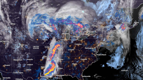
Meteorologists said that a more potent storm and high-end atmospheric river will bring major impacts that will threaten lives, property and travel into the coming week. They said that this could affect more than 37 million residents of California.
Most Rains In Southern, Central California
Weather experts warned that due to the numerous mountains and hills, even just a few inches of rain could bring significant floods in the area.
The National Weather Service said that most of the rains will be felt in portions of Southern and Central California. The first storm that hit the area had brought a general 1-6 inches of rain.
However, starting as early as Saturday night, more than double the amount of rain may fall and be felt from the new storm. Based on weather forecast, some of the rainiest spots picking up a foot or more of rain in only 48 hours.
Meanwhile, mountain snow and a rain or snow mix for lower elevation valleys will continue across the West as an upper-level trough and accompanying surface frontal system will push eastward through the Great Basin and Rockies.
A secondary upper-level trough or area of low pressure offshore of the Pacific Northwest will also keep weather unsettled along the West Coast.
On the other hand, a heavy higher elevation snow is expected for many of the local mountain ranges across the West including in California, the Great Basin, and the Rockies. This will likely see at least a foot of new snow through Sunday morning.
Accumulations is expected to be lighter for most lower elevations, and any snow that mixes in should lead to little to no accumulations.
Some heavier showers will be possible along the northern California and the southern Oregon coast where thunderstorms are expected.
As the system advances further to the east precipitation chances will decrease for California and the Great Basin on Saturday.
Read Also: Snow Expected in UK Next Week as Arctic Blast Brings Freezing Temperatures
Heavy Snow In Rockies
Meanwhile, the heavy snow across the Northern and Central Rockies will persist.
Weather experts also said that the first wave of heavy precipitation associated with another Atmospheric River may begin to impact portions of California as early as Saturday night, and likely by Sunday morning.
The central portions of the country will also have an amplified upper-level ridge in place that will maintain above average temperatures for the Plains and the Midwest.
Meteorologists said that the daily maximums would range from the 30s to 40s for the Northeast and the Great Lakes, the 40s and 50s for the Northern Plains and the Ohio Valley, the 50s and 60s for the Central Plains and Carolinas, and the 60s and 70s for the Southern Plains and Southeast.
Temperatures will remain on the cooler side of average across much of the West given the upper-level trough, cloudy cover and precipitation.
Highs mainly in the 40s for the Great Basin, 50s for the Pacific Northwest and northern California, and 60s for the Desert Southwest and southern California.
Related Article: US West Coast Weather update: Heavy Rain, Mountain Snow To Heighten Flood Risk
© 2024 NatureWorldNews.com All rights reserved. Do not reproduce without permission.


![Climate Change is Reducing Dust Levels Worldwide as Arctic Temperature Warms [Study]](https://1471793142.rsc.cdn77.org/data/thumbs/full/70320/280/157/50/40/climate-change-is-reducing-dust-levels-worldwide-as-arctic-temperature-warms-study.jpg)
