The National Weather Service (NWS) reported that the first atmospheric river event is expected in the Pacific Northwest this week, bringing potential snow and rain.
Pacific Northwest recorded colder temperatures and snowy conditions in high-elevation areas. The snow could bring significant dangers, including slippery road conditions, foggy outlook and winter storms.
Low humidity and wind gusts up to 65 mph across higher elevations are creating favorable conditions for fire growth and spread in areas of southern California today.https://t.co/VyWINDkBnn pic.twitter.com/7UKT5EVIQT
— National Weather Service (@NWS) October 30, 2023
Recently, Wyoming and Colorado experienced colder temperatures. A widespread hard freeze is also expected in the two areas in the early week.
In terms of snow, it will be more noticeable in mountainous areas.
Atmospheric River Event in Northwestern US
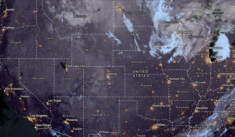
NESDIS via NOAA Satellite View as of October 31, 2023. The first atmospheric river event of the season will unload in the Pacific Northwest on Wednesday. Chance of snow and rain can be possible. Stay updated on the weather.
According to the NWS' latest advisory, the Atmospheric River event will unfold light to moderate rainfall conditions in portions of the Pacific Northwest on Wednesday.
It will be considered the first atmospheric river event of the season.
It will help with the chance of extreme rainfall in the region, which may cause potential flooding and mudslides.
The moisture from the Atmospheric River event can benefit drought-stricken areas in the Pacific Northwest and Western US. Motorists should check the weather this week for flooding concerns due to heavy rainfall.
In Southern California, the dry conditions will continue. Forecast warned of Elevated Fire Weather Risk in the region on Tuesday.
The Santa Ana Wind Event can cause significant wildfire concerns due to strong winds and low humidity. A wind gusts up to 80 mph could cause potential travel delays.
In the midweek, the milder conditions could unfold in the following areas:
- Redding
- Reno
- San Francisco
- Fresno
- Los Angeles
- San Diego
- San Diego
- Phoenix
- Las Vegas
The fire risks could reach portions of L.A and Ventura counties. The dry conditions and strong winds can become favorable in the increased fire risks in Southern California.
Also Read: Freezing Conditions, Colder Arctic Air to Hit Southeastern US, Ohio Valley Midweek
Weather in the Northeast and Midwest
Meteorologists are monitoring a clipper system that could bring potential snow squalls in the Midwest and Northeast. The snow squalls can cause significant driving concerns due to the burst of snow and gusty winds.
Motorists are advised to stay careful while driving. Driving slowly and reducing speed are recommended. Through Wednesday, the colder conditions could cause potential frost risk.
The colder weather outlook could reach the following areas:
- Portland
- Boston
- New York City
- Washington City
- Montreal
- Pittsburgh
- Charleston
- Detroit
- Sudbury
- Detroit
- Indianapolis
- Chicago
- Green Bay
- Minneapolis
Through Wednesday, the snow could unload in Burlington, Buffalo, Quebec, Chicago, Green Bay and Minneapolis. The clipper storm could cause reduced road visibility and blowing snow.
Halloween in the Midwest and Northeast could unload the snow, showing the signs of upcoming winter. However, homeowners should watch out for driving dangers and cold-related health concerns.
Related Article: Southern California's Santa Ana Event: Travel Delays, Wildfire Risks Possible Due to Strong Winds
For more similar stories, don't forget to follow Nature World News.
© 2024 NatureWorldNews.com All rights reserved. Do not reproduce without permission.
![Roundworms with Short Memories 'Stop Forgetting' When Frozen or Given Lithium [Study]](https://1471793142.rsc.cdn77.org/data/thumbs/full/70295/280/157/50/40/roundworms-with-short-memories-stop-forgetting-when-frozen-or-given-lithium-study.jpg)
