The latest forecast showed that excessive rainfall and flash flood could unload from Eastern Texas, Michigan and Northern Arkansas. Heavy rain is also expected in the Upper Great Lakes and Southern Plains.
A rainy outlook is expected in the Northeast amidst the colder conditions. Residents can expect low temperatures, including in the Ohio Valley.
Meanwhile, snow and colder weather will emerge in North Dakota, Washington and Northwestern US.
Isolated to scattered showers and storms will continue off and on overnight, but the heaviest rain is now behind us. Look for continued warm, humid conditions through Sunday morning, then a STRONG cold front with more rain chances along and behind it. pic.twitter.com/YExdSEyCiu
— NWS Austin/San Antonio (@NWSSanAntonio) October 26, 2023
In this week's forecast, the weather dangers are flash flooding, flooding, heavy rain and travel dangers. Homeowners should also stay alert for flooded roads due to excessive rainfall.
Excessive Rainfall and Flash Flood Risk: Where Will It Impact?

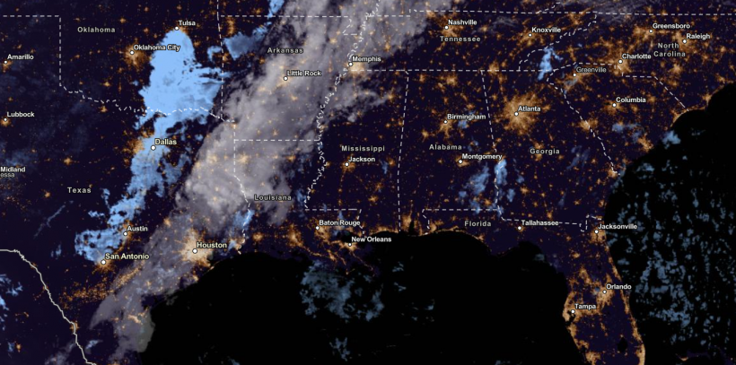
NESDIS via NOAA Satellite View as of October 27, 2023. Flash flood and excessive rainfall are expected from Eastern Texas, Michigan and Northern Arkansas this week. Isolated thunderstorms can likely emerge.
According to the National Weather Service (NWS), the flash flood risk and excessive rain are likely in Eastern Texas, Northern Michigan and Eastern Wisconsin.
Heavy rainfall can trigger small to severe flooding, especially in flood-prone and low-lying areas. Thunderstorm conditions could also spread over portions of Northeastern Texas, Western Arkansas and ArkLaTex.
On the weekend, the flash flood concerns could unfold in Northern Arkansas and Southern Missouri, including in parts of Oklahoma.
In addition, the NWS Austin/ San Antonio reported that moderate to heavy rainfall could unfold in the region. Rainy outlook could unload in the I-35 corridor and coastal plains region.
Meanwhile, temperature lows could emerge from the Upper Great Lakes and Southern Plains. In the Southeast, an approaching cold front in the Central US will bring a warmer outlook.
In the Central US, the colder weather could unfold on Friday in the following areas:
- Fargo
- Minneapolis
- Sioux Falls
- Omaha
- Kansas City
- Wichita
- Oklahoma City
- Lubbock
- Denver
- Scottsbluff
On the weekend, the change in the weather pattern would emerge in the following areas:
- Nashville
- Raleigh
- Atlanta
- Montgomery
- Jackson
- Dallas
- Lubbock
On Saturday, the ice potential is expected in Salina, Dodge City and Wichita. Freezing conditions could unfold in Texas, Oklahoma and Kansas. The rain will become beneficial for drought-affected areas.
Also Read: Thunderstorms, Excessive Rainfall to Hit Southern Plains, Upper Great Lakes in US This Late Week
Flash Flood Risk, Heavy Rainfall: How to Keep Safe
According to the latest forecast, flash flood risk and heavy rain can fall in the said areas. Excessive rain can trigger flooding, especially in flood-prone areas.
The main risk will be travel dangers due to slippery and flooded roads. As Halloween comes near, motorists should stay updated with the latest forecasts.
Here are safety reminders for keeping safe from excessive rainfall and flash floods.
- Homeowners should stay away from flooded roads or areas. River or creek flooding is also possible with potential flash flood risks.
- When the rain intensifies, homeowners should stay at home and wait until the weather improves.
- As the weather improves next week, homeowners should still bring an umbrella or raincoat jacket.
Stay updated with the latest forecast in Nature World News in November.
Related Article: Foggy Conditions, Colder Temperatures to Hit Colorado; Winter Advisories Present in Wyoming
For more similar stories, don't forget to follow Nature World News.
© 2024 NatureWorldNews.com All rights reserved. Do not reproduce without permission.

![Tsunami Hazard Zones: New US Map Shows Places at Risk of Flooding and Tsunamis Amid Rising Sea Levels [NOAA]](https://1471793142.rsc.cdn77.org/data/thumbs/full/70325/280/157/50/40/tsunami-hazard-zones-new-us-map-shows-places-at-risk-of-flooding-and-tsunamis-amid-rising-sea-levels-noaa.jpg)


