Hurricane Otis wreaked havoc as it made its way towards Mexico, leaving trails of destruction in the homes and facilities across the country.
The weather system unleashed heavy rains toward the country's resort city Acapulco.
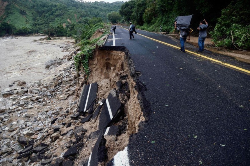
Effects Of Otis
The damage buildings and vehicles were observed to partially submerged in floodwaters. Authorities in the southern state of Guerrero had attempted to take a measure of the damage.
Furthermore, the loss of communications was also reported due to the damaged infrastructure and electricity cuts.
Meanwhile, the country's Federal Commission for Electricity said that around 300,000 individuals were still without power supply.
Authorities said that while storm shelters were opened to the public, there was a little time for the people to prepare for the bad weather and it has prompted fears of a large number of casualties among the public.
According to Mexico President Andrés Manuel López Obrador, no loss of life had been reported so far, but he noted that there was still "no communication" within the affected area.
Officials said that around 850,000 people reside in Acapulco, and many tourists and delegates to a mining conference were in town when the hurricane struck the area.
They noted that smaller fishing towns along the coast as well as the communities inland were also in the path of the storm.
Read Also : Hurricane Otis To Strike Mexico With Risky, Damaging Flash Floods, Mudslides As Category 5
Weather Track
The National Hurricane Center and Central Pacific Hurricane Center said that at 400 PM CDT (2100 UTC), the remnants of Otis were located near latitude 19.1 North, longitude 100.8 West.
The remnants are forecasted to be moving toward the north-northwest near 10 mph (17 km/h) and this general motion is expected to continue tonight.
Meanwhile, maximum sustained winds are near 35 mph (55 km/h) with higher gusts while the estimated minimum central pressure is 985 mb (29.09 inches).
When it comes to the amount of rainfall, the remnants of Otis are expected to produce additional rainfall totals of two to four inches (locally as high as 6) through Thursday across Guerrero, Mexico, and Morelos.
A rainfall total of nine inches was already observed at Cigua de Benitez in the state of Guerrero.
This rainfall is also seen to produce flash and urban flooding, along with mudslides in areas of higher terrain.
Authorities said that the government of Mexico has discontinued the tropical storm warning from Punta Maldonado to Acapulco. So far, there are no coastal watches or warnings in effect.
The remnants of Otis is seen to continue to produce locally heavy rains and flooding through Thursday.
Officials said that Otis is Mexico's third hurricane in a matter of weeks after Norma struck Sinaloa, leaving three people dead. On the other hand, Lidia left at least two dead in the states of Jalisco and Nayarit.
They said that due to the long coastlines in the Pacific and the Atlantic, Mexico is considered as one of the countries that is most vulnerable to hurricanes.
Climate scientists and experts have already warned that extreme rapid intensification, which was observed with Otis, has been made more likely by climate change and warming oceans.
Related Article : Hurricane Tammy Pummels North Caribbean with Large Waves, Heads Toward US by End of Week
Related Video:
© 2026 NatureWorldNews.com All rights reserved. Do not reproduce without permission.


