Weather disturbance Ophelia has made landfall near Emerald Isle, North Carolina on Saturday.
Meteorologists categorized Ophelia as a tropical storm when it had made landfall, packing maximum sustained winds of 70 mph.
Ophelia had resulted in dangerous sea conditions prompting the evacuation of those residing in coastal areas.
Moreover, a major flash flood event also took place over Greenville, North Carolina.
Tropical depression
The National Hurricane Center and Central Pacific Hurricane Center said that the center of Ophelia, which is now categorized as a post tropical cyclone, was located at 1100 PM EDT (0300 UTC)near latitude 37.1 North, longitude 77.6 West.
The weather advisory indicated that Ophelia is moving toward the north near 8 mph (13 km/h).
Meanwhile, on the forecast track, the center of Ophelia is expected to turn toward the north-northeast and northeast, moving across eastern Virginia and the Delmarva Peninsula through Sunday.
Weather experts said that the maximum sustained winds are near 35 mph (55 km/h) with higher gusts.
Little change in strength is also forecasted during the next day or so.
The post-tropical low is expected to become absorbed by a frontal boundary Sunday night or early Monday.
Meanwhile, the estimated minimum central pressure is 1003 mb (29.62 inches).
Ophelia's combination of storm surge and the tide would later cause normally dry areas near the coast to be filled by rising waters that were moving inland from the shoreline.
The water could reach the following heights above ground somewhere in the indicated areas if the peak surge happens at the time of the occurrence of a high tide.
Meteorologists said that the deepest water would occur along the immediate coast in areas ofonshore winds, where the surge will be accompanied by dangerous waves.
The surge-related flooding depends on the relative timing of the surge as well as the tidal cycle, and can vary greatly over short distances.
Residents have been advised to seek more information about their area from forecasts released by their local National Weather Service forecast office.
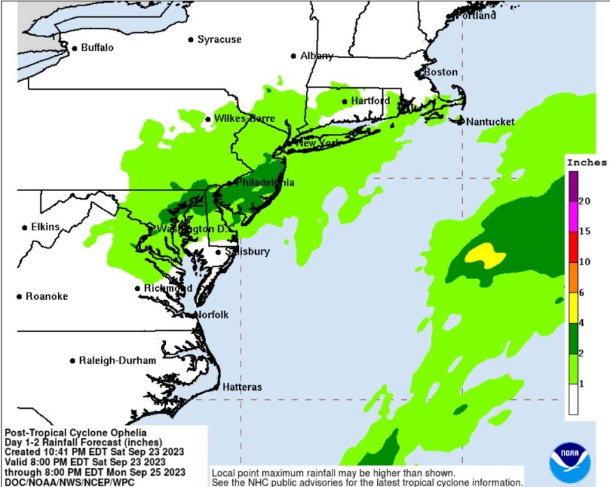
When it comes to the amount of rainfall, Ophelia is still expected to produce additional rainfall through Sunday night, including over portions of the Mid-Atlantic from north central North Carolina through New Jersey (1 to 3 inches with isolated higher totals up to 5 inches) as well as in areas across southeastern New York through southern New England (1 to 3 inches).
Meteorologists said that the rainfall could result in locally considerable flash, urban, and small stream flooding impacts, particularly the areas across the Mid Atlantic region from North Carolina to New Jersey.
Furthermore, isolated river flooding is possible in areas that will encounter more torrential downpours.
Gusty winds to tropical storm force are still possible near the coasts of North Carolina and Virginia during the next few hours.
Meanwhile, the swells generated by Ophelia would continue to have an impact towards much of the east coast of the United States through the weekend. These swells are likely to cause life-threatening surf and rip current conditions.
Experts further warned that a tornado or two could occur through tonight across parts of the Mid-Atlantic Coast.
Effects
A major flash flood event also took place over Greenville, North Carolina due to Ophelia.
Some communities along the waterfront in New Bern, North Carolina, were also inundated, with officials warning that the worst conditions could still be experienced over the weekend.
Meanwhile, a storm surge was also experienced in Bethany Beach, Delaware.
Related Article : 'Homebrew' Tropical Disturbance Threatens US East Coast by Weekend
Related Video:
© 2026 NatureWorldNews.com All rights reserved. Do not reproduce without permission.


