Meteorologists warned that a coastal storm could bring heavy rains and floods in New England.
They said that the storm has been moving towards the direction of mid-Atlantic and New England coast beginning this week, noting that it might cause floods anew in the areas that were impacted by Lee.

The additional rains in New England is seen to disrupt transportation in the area.
Officials said that most of the areas battered by Lee in southern New England have been on their road to recovery after experiencing torrential rains last week.
However, the latest rainfall that they may experience early this week could again bring localized floods, especially in low-lying and poor drainage areas, streams and smaller rivers.
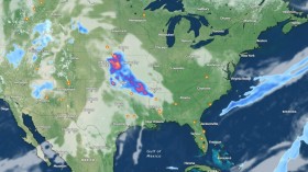
Forecast track
The National Weather Service said that shower and storm chances along the East Coast confine to New England on Monday and that the unsettled weather and severe storm chances are seen to make its way back to some parts of the Southern Plains on Tuesday.
The NWS said that a marginal risk has already been issued from eastern Connecticut to Maine due to the threat of a few inches of rain within a relatively short period of time.
Residents and visitors are reminded to be vigilant about weather advisories and avoid driving through flooded roadways.
The storm, which pushes northeastward across the Southeastern states, is seen to move up the coast through Tuesday, which may possibly spread anywhere and bring between one to two inches of rain to some areas of Connecticut, Rhode Island, eastern Massachusetts, southeastern Vermont and southeastern Maine.
On the other hand, areas situated across coastal and eastern Maine may also encounter additional rainfall after observing nearly up to six inches of downpour from Friday night to Monday.
Weather experts noted that it would only take upwards of one inch of rain over the course of a few hours in some portions of central and eastern Maine to bring some localized flash floods.
Meanwhile, it was also observed that the wet conditions would gradually shift northeastward throughout the day on Monday due to the center of the storm moving along coastal New England.
Weather experts said that some locations across Delaware, Maryland and far eastern Pennsylvania would be dry out before the middle of the morning.
Furthermore, high pressure is also expected to move in behind the coastal Northeast storm, which will later bring a return of calm, dry and mostly sunny conditions within the region.
A high pressure weather system is defined as a clockwise flow of dry, sinking air that typically builds into a region behind a departing storm system.
High pressure systems can be linked to the jet stream by finding areas where the jet bulges northward.
Temperatures are also expected to rebound by a few degrees as the week continues towards a warmer air mass.
Many locations, such as Washington, D.C., and Pittsburgh, are seen to encounter an increase of a few degrees above typical mid-September values through at least Thursday.
In these areas, dry weather is mainly expected.
Read Also: Hurricane Lee Becomes 'Monstrous,' Topples Down Power In Nova Scotia
Last advisory for Lee
So far, the center of Post-Tropical Cyclone Lee was located near latitude 48.0 North, longitude 62.0 West.
Lee is seen moving toward the northeast near 22 mph (35 km/h), and a faster northeastward to east-northeastward motion is expected in the next couple of days.
Meteorologists said that maximum sustained winds are near 45 mph (75 km/h) with higher gusts.
The continued gradual weakening is forecasted during the next couple of days, and Lee is seen to dissipate on Tuesday.
Related Article: Hurricane Lee at Category 3: New England, Atlantic Canada Brace for Damaging Winds
Related Video:
© 2024 NatureWorldNews.com All rights reserved. Do not reproduce without permission.


![Roundworms with Short Memories 'Stop Forgetting' When Frozen or Given Lithium [Study]](https://1471793142.rsc.cdn77.org/data/thumbs/full/70295/280/157/50/40/roundworms-with-short-memories-stop-forgetting-when-frozen-or-given-lithium-study.jpg)