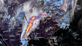
According to the latest forecast, the Northeastern US will experience possible rain and thunderstorms this week due to potent storms and an approaching cold front.
The rainy conditions will be affecting residents this Monday, Sept. 11.
All flood advisories have been allowed to expire as the heavy rain is pushing off to the east and northeast. There very well may be another round of heavier rainfall late tonight as another upper level disturbance pushes through. #ctwx #liwx #nywx #hvwx #njwx #nycwx pic.twitter.com/sbx2HfY249
— NWS New York NY (@NWSNewYorkNY) September 10, 2023
Residents in the Northeast should keep updated with the weather, especially with travel plans or outdoor activities this week. The excessive rainfall could also impact the Central Plains and Mid-Atlantic.
The rainy outlook could result in the following:
- Landslides
- Flooded roads, especially for low-lying or flood-prone areas
- Mudslides
Northeast excessive rainfall: Where will it impact?
Heavy to excessive rain possible along frontal boundaries in the Mid-Atlantic/Northeast & central Plains. Dangerous heat persists in the Southwest, TX, & PR. #Lee and post-tropical #Jova producing dangerous surf/rip currents in CA, PR, & USVI. pic.twitter.com/XiimeQ561Q
— National Weather Service (@NWS) September 10, 2023
As dangerous heat looms over the Southwest and Texas, the cold front and potent storm will unleash excessive rainfall in the Northeastern US starting Monday.
Scattered flash flooding is also likely over the Central Appalachians and New England.
According to the latest forecast, last week's potent thunderstorms and low pressure would also help to bring the rainy conditions to the Northeast.
On Monday, the rainy outlook could be likely in the following areas:
- Portland
- Boston
- New York
- Washington
- Burlington
At least one to two inches of rain could be possible in the affected areas, especially in the New England to Mid-Atlantic States.
In New York City, flooding advisories are present in the area due to the heavy rain. On September 10, special weather advisories were issued in the following areas:
- West Babylon NY
- Central Islip NY
- Brentwood NY
- Hampton Bays NY
- Riverhead NY
- Southold NY
- Portland CT
The wet weather outlook can persist until the midweek. On Tuesday, the rain could unfold in the following areas:
- Washington
- Charleston
- Pittsburgh
- Detroit
- Columbus
- Buffalo
- Portland
In Southern Utah and National Parks, recreational areas are also at risk of flash flooding and rain conditions.
Meanwhile, the rain, thunderstorms, and cold front in the Northeast could help bring cooler conditions. Temperatures could likely fall between five to 10 degrees in the Northeast.
In California and Mexico Coast, The National Hurricane Center reported that Post-Tropical Cyclone Jova is forecast to unleash rip currents and dangerous surf.
Also Read: US Weather Forecast: Severe Thunderstorms To Bring Relief From Heat to Northeast This Weekend
How to keep safe from excessive rainfall this week
The latest weather outlook showed that excessive rainfall could be likely in the Northeast, New England, and Mid-Atlantic. While the relief is on the way due to a cold front, the rain could result in challenging flooding conditions.
Homeowners should keep updated with the Northeastern weather forecast, especially for flood-prone areas. Here are essential reminders to stay safe from excessive rainfall outlook.
Watch out for flooding concerns
One of the main concerns is flooding this week due to excessive rainfall. Flooded roads are also possible. Travelers should check the road conditions or it is best to limit outdoor activities when weather improves.
Related Article: Global Impact of Extreme Weather Events: Climate Change Can Intensify Frequent Hurricanes, Drought, Wildfires
For more similar stories, don't forget to follow Nature World News.
© 2024 NatureWorldNews.com All rights reserved. Do not reproduce without permission.

![Tsunami Hazard Zones: New US Map Shows Places at Risk of Flooding and Tsunamis Amid Rising Sea Levels [NOAA]](https://1471793142.rsc.cdn77.org/data/thumbs/full/70325/280/157/50/40/tsunami-hazard-zones-new-us-map-shows-places-at-risk-of-flooding-and-tsunamis-amid-rising-sea-levels-noaa.jpg)


