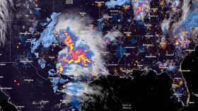
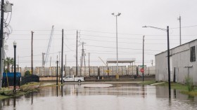
Severe storms with heavy rain, large hailstones, and damaging winds have struck multiple parts of Australia, including communities in the east coast.
In Queensland, severe thunderstorm warnings are in place from the Sunshine Coast to the Gold Coast.
Australian weather authorities have issued storm warnings and forecasted that the stormy weather will continue as the week progresses.
Severe Storms and Heavy Rain

The Bureau of Meteorology (BoM) on Tuesday, November 29, states that large-scale rainfall and thunderstorms are possible across northern Australia and will spread to much of Queensland this week.
There is a risk of inland flash flooding, riverine flooding and strong winds, potentially causing power outages, travel disruption, and infrastructural damage affect homes and businesses.
The latest Australia weather forecast comes a day after the BoM issued a media release on Monday, November 28, warning of the dangers of showers and potential severe thunderstorms across the eastern and northern portions of Queensland.
Also Read: Monster Storm Warning Issued for Australians as Heavy Rainfall Expected Next Week
Severe Thunderstorm Warnings
Since Monday, rain showers and storms developed over the Kimberley and Top End areas of Queensland, northeast areas of New South Wales, and Western Australia.
With this, the BoM said severe thunderstorm warnings have been issued in the following areas for heavy rain and damaging winds:
- Urannah, Queensland
- Kenbula, Queensland
- Glen Duh Road, Queensland
- Craiglands, Queensland
- Red Hill, Queensland
- Trafalgar Station, Queensland
- Ngukurr, Northern Territory
- Jambin, Queensland
- Merlin Mine, Northern Territory
- Eight Mile Mill, Western Australia
In general, rainfall amount between 30 to 60 millimeters was observed across the southeastern and central Queensland, northwestern Top End, and northeastern Kimberley.
The inclement weather will increase for Queensland and New South Wales from Wednesday to Thursday, November 30 to December 1.
In local sources, Australia's 9 News media agency on Tuesday cited a statement from local authorities that the first tropical storm of the current season has struck Australia's east coast with large hail and heavy rainfall.
A storm warning for large hailstones were also issued in some areas, including the Tropical Coast, Tablelands, and Wide Bay Burnett.
Australia Weather Outlook
These severe weather conditions come as the Australian spring season will come to an end this month.
In contrast to the Northern Hemisphere, Australia has its summer season from December to February.
However, the country has witnessed a generally wet weather during summer in recent years, wherein the La Nina weather phenomenon is reportedly responsible for causing heavy rain and flooding.
On November 24, the Australian government weather agency issued its long-range forecast overview, a climate outlook for December to March which suggests the continuance of the wet weather in Eastern Australia, which was battered several times this year with La Nina-driver torrential rain and floodwaters.
The long-range climate report said that rainfall from December to February is likely or greater than 60% chance to be above the median level for the Queensland coast, northern coast and southern New South Wales, southeastern South Australia, and eastern Tasmania.
Meanwhile, below median rainfall is likely for parts of Western Australia, relatively receives lesser rainfall compared to its counterpart.
Related Article: Storm Alert: Heavy Rain and Thunderstorms Forecasted for Eastern Australia This Week
© 2024 NatureWorldNews.com All rights reserved. Do not reproduce without permission.
![Venomous Centipede Could be Game-Changer and Save Lives of People with Kidney Disease [Study]](https://1471793142.rsc.cdn77.org/data/thumbs/full/70407/280/157/50/40/venomous-centipede-could-be-game-changer-and-save-lives-of-people-with-kidney-disease-study.jpg)
![Plastic Pollution: Scientists Include Spores of Plastic-Eating Bacteria ‘Bacillus Subtilis’ to Develop 'Self-Digesting Plastic' [Study]](https://1471793142.rsc.cdn77.org/data/thumbs/full/70396/280/157/50/40/plastic-pollution-scientists-include-spores-of-plastic-eating-bacteria-bacillus-subtilis-to-develop-self-digesting-plastic-study.jpg)