New South Wales is expected to see severe storms and rain, which might obliterate the snow cover in the alpine area and increase the risk of flooding in the state's southeast.
It happens as thick fog, which on Thursday morning engulfed south-east Queensland, delayed flights.
After a "nightmare" winter of rain and flooding, authorities and farmers in Queensland are prepared for a soggy spring.
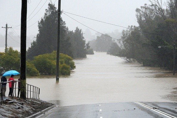
Heavy rainfall in NSW and Queensland
 (Photo : MUHAMMAD FAROOQ/AFP via Getty Images)

This Monday, the Bureau of Metrology proclaimed the Indian Ocean Dipole to be "negative," which normally indicates that areas of southern and eastern Australia would see rainier-than-normal winter and spring weather, as per ABC News.
La Nina may recur a third time throughout the spring, according to the agency.
Jake Hamilton, a farmer in Condamine, said the prognosis had him a little worried after his southern Queensland property had an "absolutely horrible" winter of muddy paddocks.
More than 150 millimeters of rain fell on Hamilton's property in May, he claimed, badly delaying the planting of crops.
Overall, the season, according toHamilton, was all farmers could have dreamed of.
However, he cautioned that if the predicted rainy spring materialized, it may make plant disease issues worse. He claimed that when coupled with a fungicide scarcity, it might cause considerable crop losses.
But ultimately, it's only a projection, Hamilton noted.
Experts stated that the possible rainfall for Thredbo today is up to 200mm and that the rain is predicted to significantly reduce the amount of snow cover in mountainous regions "because it's pretty warm and it's not falling as snow, it's falling as rain."
Due to the weather, Thredbo has shut down all of its lifts.
In the Illawarra, southern tablelands, Hunter, south coast, central tablelands, north-west slopes and plains, central west slopes and plains, south-west slopes, Snowy Mountains, and Riverina, the bureau is issuing a flash flood warning due to heavy rain.
Because so much water is trapped in snow and ice, the melting snow might increase the flood danger in the area surrounding the Snowy Mountains, as per The Guardian.
Once the snow begins to melt, it will increase the anticipated rainfall, especially in the upper Murray Valley and along all of the tributaries that flow into the Murrumbidgee River and the Murray River in the southern tablelands, which truly refers to the alpine region.
For locations including Braidwood, Goulburn, Bombala, Tumbarumba, Tumut, Khancoban, and Thredbo top station, a flood watch is now in effect.
Volunteers in Wagga Wagga are getting ready for riverine flooding of the Murrumbidgee River between Tumut and Gundagai, according to NSW SES superintendent Barry Griffiths.
How claimed that a ridge of high pressure over the state's southeast, which is bringing calm conditions and little winds, was to blame for the fog.
At Brisbane, Amberley, and Archerfield airports, visibility was reported to be only 100 meters on Thursday morning.
Jonathan How, a forecaster at the Bureau of Meteorology, stated that Adelaide is still under the destructive wind warnings for areas of south-east Western Australia and the South Australian coast.
According to him, there will be more damaging winds on Thursday along with "quite a showery pattern straight over the south of Australia," but things should clear up later on Thursday and into Friday.
Also Read: NASA: Climate Change Will Cause More Rainfall in Tropical Regions
Wet summer
Authorities have already been preparing for a rainy spring, since more than 20 people have already died as a result of flooding in Queensland this year.
Sunwater, the owner of the dams, said that 11 of its 19 reservoirs in Queensland were at or near capacity.
Colin Bendall, executive general manager of operations at Sunwater, warned that if further early spring or summer rain was forecast, communities needed to be on guard.
As part of our preparedness, Bendall stated, they have been holding drills with the neighborhood disaster management organizations and the Bureau of Meteorology.
In the case of any more dam leaks, he said that staff members were being educated in the implementation of emergency response plans.
According to meteorologist Chelsea Jarvis from the University of Southern Queensland, there is a 65% to 80% possibility that areas like the Darling Downs may receive more rainfall than average.
She said that experts will keep an eye on the issue to see if the Indian Ocean Dipole became stronger as the year came to a close.
Whether this Indian Ocean Dipole event ends in October or December, it can also affect how likely it is that it will rain throughout the coming summer, according to Jarvis.
Related article: Heavy Rainfall Persist in Southeastern US, Increasing Risks of Flash Flood
© 2024 NatureWorldNews.com All rights reserved. Do not reproduce without permission.

