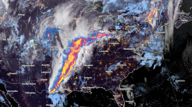
Images posted online depicted how the sky in South Dakota turned a particular shade of green as violent storms moved toward Sioux Falls.
High water content in the clouds, according to experts, is to blame for the incident.
Locals saw thunderstorms that brought strong winds and more than three inches of rain to the Sioux Falls region on Tuesday in a rarely seen shade of green.
The National Weather Service (NWS) said that severe weather was a part of a derecho, which is a prolonged chain of linked storms with winds greater than 58 mph.
In some parts of South Dakota, the storm's winds gusted as high as 99 miles per hour.
In numerous social media posts, dramatic pictures of the eerie green sky and threatening storm clouds moving toward Sioux City in the late afternoon and early evening were shared.
Certain Shade of Green
Heather Brinkmann tweeted the words, "GOODNESS GREEN." Her tweet continued on to say that as powerful storms move through Sioux Falls, the sky is turning green.
Some Twitter users expressed their astonishment as they have not seen such a sky, while some expressed much bewilderment, saying that the color of the sky is "unreal."
Reed Timmer, a meteorologist featured in Storm Chasers also took to Twitter to give an update saying that The wind bag derecho that passed through Sioux Falls earlier has caused a "crazy" greenage.
Read also: Strange Cloud Patterns Above Alaska Have Sparked a Flurry of Conspiracies
High Water Content
NWS meteorologist Cory Martin posted a tweet with an infographic explaining how the blue water droplets in the storm clouds interacted with the sun's reddish light to produce the striking visual in response to the "incredible" and unusual color of the sky.
Martin's shared infographic explained that Most thunderstorms occured later in the day when the sky turns a subdued shade of red as the sun slowly descends toward the horizon.
The blue light will be primarily scattered by storm cloud particles with significant depth and water content.
The blue water or ice droplets within the cloud will appear to glow green when the reddish light that the atmosphere scatters reflects upon them.
It takes a significant amount of water content within the cloud to produce this color, which typically denotes the presence of significant amounts of ice or large hail.
This phenomenon frequently serves as a visual indicator of a thunderstorm's potential to produce very large hail, Newsweek reported.
While distributing the infographic, Martin noted that there were not many reports of significant hail in the Sioux Falls storm.
Later, the NWS Sioux Falls Twitter account reposted Martin's tweet and added a comment saying that the majority of hail reports in the area were ice that was less than an inch thick.
According to PowerOutage.US, more than 28,000 South Dakota residents lost power as a result of the storms, but about 20,000 had their power restored by later on Tuesday night.
The storms came from the west and moved into Sioux Falls before leaving South Dakota and moving into southwestern Minnesota and northwestern Iowa.
Related article: Forest Areas Does Not Always Cause Cloud Formation, Reveals New Study
© 2024 NatureWorldNews.com All rights reserved. Do not reproduce without permission.

![Tsunami Hazard Zones: New US Map Shows Places at Risk of Flooding and Tsunamis Amid Rising Sea Levels [NOAA]](https://1471793142.rsc.cdn77.org/data/thumbs/full/70325/280/157/50/40/tsunami-hazard-zones-new-us-map-shows-places-at-risk-of-flooding-and-tsunamis-amid-rising-sea-levels-noaa.jpg)


