Tropical Storm Agaton, internationally known as Tropical Storm Megi, made landfall in the Philippines, bringing heavy rain and strong winds.
Although Megi has reportedly weakened based on the latest updates, the storm still poses a threat to the country's major islands of Visayas and Mindanao.
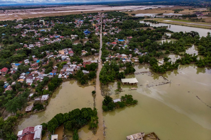
Tropical Storm Agaton
Megi formed in the western Pacific Ocean as a low-pressure area last week.
After making its entry into the town of Guiuan, Calicoan Island, on Sunday, April 10, Megi became the first storm in the Philippines this year.
The tropical storm has maximum sustained winds of 65 kilometers per hour (kph) and gust winds of up to 90 kph as of Monday, April 11.
In addition, it was last seen over the coastal waters of Mayorga, Leyte.
The Philippine Atmospheric, Geophysical, and Astronomical Services Administration (PAGASA) stated that Megi has "slightly weakened" but forecasted it is due to make its second landfall on the eastern coast of Leyte, as cited by local news site ABS-CBN News.
Related Incidents
Storm-related incidents have been reported in some parts of the central and southern Philippines as Megi continues to pass through the country in a slow phase.
The exact date and time of its exit point is not yet clear at this time.
In the Visayas, the commercial vessel MV Mika Mari 1 docked at the Consuelo Port in Camotes Island in Cebu port was submerged in water.
All 14 crew members of the ship have managed to escape and there were no reported casualties.
However, the ship was carrying more than 5,000 liters of diesel fuel and 68 liters of lube oil.
The sinking was due to large waves and strong winds brought by Tropical Storm Megi (Agaton), according to Capt. Alvin Dagalea of the Philippine Coast Guard (PCG) Cebu Station, as cited by the Philippine Daily Inquirer.
In Mindanao, one person died due to torrential rain and flash floods in Davao de Oro or Compostela Valley in the Davao Region.
The Davao de Oro provincial government has declared a state of calamity until further notice.
Rainfall forced residents in low-lying areas to evacuate the region, as per CNN Philippines.
In addition, Megi has caused agricultural damage in the region worth ₱150 million ($2.8 million).
Tropical Cyclone Wind Signals
Hurricane-like winds are the greatest threat to the current tropical storm.
As a result, the local weather agency Philippine Atmospheric, Geophysical, and Astronomical Services Administration (PAGASA) issued several Tropical Cyclone Wind Signals (TCWS) Signals No. 1 and No. 2 in some parts of Visayas, Mindanao, and an area in the southern Luzon island, as cited by ABS-CBN News.
The following areas are under TCWS Signal No. 2:
- Eastern Samar
- Southern Samar
- Biliran
- North-Central Leyte
- Northern Dinagat Islands
Other areas affected by TCWS Signal No. 1 include southern Masbate, northern Samar, southern Leyte, northern Cebu, Surigao del Norte, and the rest of the Dinagat Islands.
Typhoon Season
The occurrence of storms in the Philippines is usually prevalent during the typhoon season, which spans from July to November each year.
The eastern coastal areas of the country are the most vulnerable sites since most storms from the western Pacific Ocean make landfall in these locations.
The impact of storms in the Philippines can range from moderate to severe, especially in low-lying and mountainous areas due to flooding and landslides.
Communities near the eastern waters are also vulnerable to storm surges.
In 2013, Super Typhoon Yolanda (internationally called Super Typhoon Haiyan) caused the largest storm surge in the Philippines, with up to four meters of ocean waves hitting the city of Tacloban in Leyte; destroying most of its structures and killing thousands of people.
© 2026 NatureWorldNews.com All rights reserved. Do not reproduce without permission.


