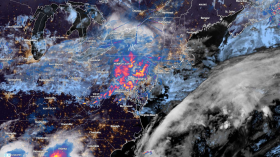
An Atlantic storm formed over the Atlantic Ocean, off the east coast of Florida on Sunday, Feb. 6.
The formation transpired during the aftermath of winter storm Landon.
The storm has been forecasted to bring only minimal impact with occurrences of light snowfall and rain showers until Tuesday, Feb. 8.
Atlantic Storm Moving Towards the Northeast

Meteorologists are monitoring the movement of an Atlantic storm, which formed over the Atlantic Ocean, off the coast of Southeast US, as reported by AccuWeather on Sunday.
The AccuWeather report described the Atlantic storm as "sneaky" since the storm formed off the east coast of Florida by the end of the weekend, just shortly after the last large-scale winter storm Landon struck the US for several days.
Although the Atlantic storm has been forecasted by the National Weather Service (NWS), meteorologists are tracking the progress of the storm due to the potential snowfall and icy conditions it may bring.
As of Sunday evening, the storm was gradually starting to form off the east coast of Florida.
Weather forecasts from both AccuWeather and the NWS indicate the Atlantic storm will move on a north-eastern pattern, navigating the Atlantic Ocean in parallel with US coastal areas.
"This low-pressure system is projected to slide just to the east of the Carolinas throughout the day Monday," says Adam Sadvary, a meteorologist from AccuWeather.
Forecasts also said the greatest risk posed by the storm will be between Monday and Tuesday, likely affecting the southeast and northeast regions.
Snowfall may occur in Bangor, Fredericton, Maine, New Brunswick-and could also extend across western Massachusetts and New Hampshire, said AccuWeather.
Furthermore, meteorologists said Boston city may experience winter hazards along its roadways in the northern and western part of the city between Monday and Tuesday.
Overall, weather forecasts say the general impact of the Atlantic storm will be low across the Southeast.
However, the Atlantic storm is expected to cause relative disruption to travel due to snowfall and icy conditions.
Also read: Winter Storm Aftermath: US Gradually Recovers, Arctic Air to Leave Midwest and Northeast
US Continues to Recover from Winter Storm Landon
The northeast and midwest regions of the US have already started to recover following the widespread disruption caused by winter storm Landon last week and throughout Saturday, Feb. 5.
Domestic and international flights across the US have gradually resumed operations following the winter storm, as per Flight Aware.
In terms of power outages, only the states of New York, Tennessee, Ohio, and West Virginia have remaining reports of outages.
Moreover, weather forecasts beyond Tuesday show that the occurrence of light snowfall and rain showers are likely to occur until Feb. 13 due to a clipper weather system, as per Allen Media Broadcasting.
Winter storm Landon has already left the US skies before Sunday.
The storm was reported to be heading the North Atlantic due to the dragging effect caused by a polar vortex, as per the Severe Weather Europe agency.
The Arctic air also shifted away from the US as the country is heading towards the end of its winter season.
Related article: Winter Storm: Blizzard Conditions Affects 100 Million People Across the US
© 2024 NatureWorldNews.com All rights reserved. Do not reproduce without permission.