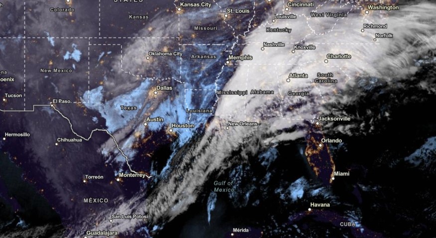
Southeast US and Gulf of Mexico can expect heavy rain and flash flooding concerns this early week, according to the National Weather Service (NWS) weather advisory.
People traveling this week should stay updated with the latest forecasts in the affected areas to keep away from flooded roads. Motorists should also anticipate slower commutes and travel concerns in the Southeast.
In the latest NWS advisory, the forecast showed that Tornado Watch is present in areas in and southern Mississippi east-central Louisiana. Last week, NWN reported the tornado threats in the Southern US. Homeowners must stay aware of Tornado Warnings, especially nocturnal tornadoes.
Weather in the Southeast and Gulf of Mexico: Where Will Stormy Conditions Unload?
According to the NWS Storm Prediction Center, severe weather conditions could unfold tornado risks in east Texas. Hail is also possible. Limiting outdoor activities is the best option to keep safe from the weather.
In addition, the hazardous weather conditions could spread in portions of the central Gulf Coast states. People are advised to stay updated with the forecasts in the region.
The NWS Hazardous Weather Outlook monitors a low pressure in the Mid-Atlantic and Gulf Coast on Tuesday. Wetter conditions can unload in the Southeast, Southern Appalachians and Gulf of Mexico. The forecast warned of excessive rainfall and flash flooding risks.
Americans living in low-lying and flood-prone areas are at risk of severe to challenging flooding, including for people near small streams and rivers.
Homeowners should also stay alert for Enhanced Risk of severe thunderstorms this week. Troublesome weather outlook could emerge in the Lower Mississippi Valley and Western Gulf Coast. A lightning strike could hit anytime.
On Monday, homeowners should watch out for a chance of heavy rainfall in the following areas:
- Roanoke
- Charlotte
- Charleston
- Jacksonville
- Atlanta
- Montgomery
- New Orleans
- Houston
- Little Rock
- Nashville
- Huntsville
- Shreveport
- Jackson
- Virginia Beach
- Memphis
If the travel or outdoor plan is unimportant, homeowners should just stay at home until the weather finally improves. Early this week, severe thunderstorms will be accompanied by intense rainfall, hail and possible isolated tornadoes.
In addition, severe weather outlook will be likely in the following areas this week:
- Atlanta
- Augusta
- Charleston
- Columbus
- Albany
- Tallahassee
- Jacksonville
- Gainesville
Weather in Other States in the US
According to the NWS's latest advisory, higher elevation snow is forecast in the Northwestern US to Northern Plains. Snowy conditions are likely in the Northern Rockies and Northern Intermountain Region.
The snowy outlook could bring potential travel dangers, such as slippery commutes and cold-related health concerns.
Related Article : Northeastern US Weather Forecast: Major Snowstorm to Bring Potential Travel Disruption, Colder Conditions
For more similar, don't forget to follow Nature World New
© 2026 NatureWorldNews.com All rights reserved. Do not reproduce without permission.


