Weather forecasts are monitoring the potential developments of Tropical Storm Franklin, which could likely develop into a hurricane according to the latest forecast.
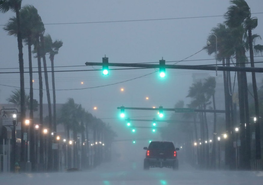
Whether Franklin could strengthen, the tropical storm could bring rainy conditions, rip currents and rough surf in parts of the East Coast U.S.
The National Hurricane Center (NHC) reminded residents of possible hurricanes, as rip currents could be possible until this week, and should only swim in designated areas to ensure safety from challenging waves or currents.
Franklin is likely to develop into a hurricane.
11AM 26 Aug: Although #Franklin is forecast to pass well offshore the east coast of the U.S. Franklin is capable of producing deadly rip currents and waves this weekend into early next week along portions of the east coast. Check the forecast before you go https://t.co/JttG4XipJ4 pic.twitter.com/NEcRIAAVoJ
— National Hurricane Center (@NHC_Atlantic) August 26, 2023
Franklin could unleash hurricane-force winds and rainy conditions in parts of Bermuda and Atlantic Canada. Residents on the East Coast could likely experience stormy conditions as well.
According to the latest forecast, Franklin was tracked over the Atlantic, moving north-northwest to reach a hurricane level. The storm managed to get 40 to 60 mph wind gusts.
As the summer season begins and many Americans plan to go on beaches, regularly checking the weather for swimming dangers this week is best.
On Wednesday, localized coastal flooding could be possible in the following areas:
- Jacksonville
- Charleston
- Wilmington
- Virginia Beach
- Ocean City
- Montauk
Tropical Storm Idalia
Furthermore, the NHC's latest advisory also warned that Tropical Storm Idalia could become a hurricane, affecting parts of the Gulf of Mexico, Florida's west coast and the Florida Panhandle.
11AM 26 Aug: Although #Franklin is forecast to pass well offshore the east coast of the U.S. Franklin is capable of producing deadly rip currents and waves this weekend into early next week along portions of the east coast. Check the forecast before you go https://t.co/JttG4XipJ4 pic.twitter.com/NEcRIAAVoJ
— National Hurricane Center (@NHC_Atlantic) August 26, 2023
Due to the tropical storm's threats, hurricane watches and storm surge watches are present in parts of Florida.
According to the forecast, urban flooding and scattered flash floods could be likely in the affected areas.
Meanwhile, flooding rainfall could unload in the Southeast in midweek.
The tropical storm could also impact parts of Western Cuba and the Eastern Yucatan Peninsula. Motorists with travel plans should check for tropical storm updates for possible travel dangers this week.
NWS Jacksonville warned that intensifying Tropical Storm Idalia could affect parts of Suwannee Valley on Tuesday or Wednesday.
While the rainy conditions could ease the hotter conditions in Florida, the risk of heavy rain could be the main problem, especially for low-lying or flood-prone areas.
The NWS Weather Prediction Center recently reported that Tropical Depression Ten strengthened to the now tropical storm Idalia.
Also Read : US Weather Forecast: At Least 100 Million People in Central Portions Under Heat Advisories
Staying safe from hurricane conditions this week
The latest forecast noted that hurricanes can become powerful and deadly, and it is essential that homeowners should prepare to stay safe from weather dangers.
In the final days of August, the risk of flooding or flash floods could become dangerous. Homeowners and motorists should regularly check the latest weather, especially for possible evacuations.
Power outages could happen due to strong winds. It is advisable that homeowners keep emergency kits, including flash flights, non-perishable goods, medicines and bottled water.
Related Article : US Weather Forecast: Hotter Weather to Hit Southern US; Cooler Conditions Likely in Northeast
For more similar stories, don't forget to follow Nature World News.
© 2026 NatureWorldNews.com All rights reserved. Do not reproduce without permission.


