Merapi volcano in Indonesia erupted on Tuesday, May 23, emitting ash and lava during broad daylight with clear skies, according to reports. This means a number of locals vividly saw the volcanic eruption, which spewed a chunk of molten rock. There were no immediate reports of evacuations in the area, as well as casualties. However, the threat of a major eruption remains possible.
May 23 Merapi Volcano Eruption
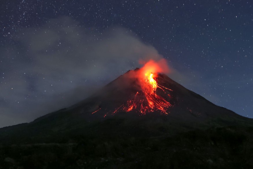
One of the world's most active volcanoes, Mount Merapi spewed lava that reached a distance more than 2 kilometers from its crater, Channel News Asia reported on Tuesday. Images of the latest eruption were published by the Merapi Volcano Observatory, a government-run organization.
Based on the report, dozens of small tremors or volcanic earthquakes occurred in relation to the Mount Merapi volcano eruption on Tuesday, according to the Centre for Research and Development of Geological Disaster Technology, another government agency that monitors Merapi.
The agency's head Agus Budi Santoso stated Merapi's seismic activity increased in the past few days and these kinds of heightened activities often occur in the volcano, as cited by CNA.
Where is Mount Merapi?
Mount Merapi, locally known Gunung Merapi, is located between the Central Java province and Yogyakarta special region. Specifically, it is located near the center area of the Java island and north of the provincial city of Yogyakarta. Since 1548, the volcano has erupted regularly, with some involving deadly and cataclysmic explosions.
The last major eruption of Merapi volcano occurred in October 2010, wherein it initially killed at least 13 people when it poured hot ash and released "searing clouds of hot gases" into its surrounding villages, according to the Asian Disaster Reduction Center (ADRC).
By November 2010, the total death toll reached almost 100 and forced the evacuation of 75,000 from the area, the ADRC. Overall, more than 300 people died from the 2010 eruption which led to the evacuation of around 280,000 residents across the region.
Since then, volcanologists have continued to monitor the activities of Merapi, which showed signs of renewed potential last year for the next major eruption sooner or later.
Pacific Ring of Fire
Indonesia sits within the 'Pacific Ring of Fire.' It is a horseshoe-shaped region in the Pacific Ocean that spans multiple countries in East Asia, Southeast Asia, Oceania, and the Americas.
The said geologic location of Indonesia makes it prone to frequent earthquakes and volcanic eruptions. Since the Ring of Fire consists of dynamic seismic activities due to the constant movement of tectonic plates.
In September 2009, a powerful 7.0 magnitude earthquake occurred in Indonesia's West Java island, killing multiple people and leading to the displacement of thousands. According to its local government, approximately 80% of the houses in the region were destroyed, as cited by the United Nations' ReliefWeb.
© 2026 NatureWorldNews.com All rights reserved. Do not reproduce without permission.


