After blanketing parts of the Plains, West, and Midwest over the past few days, Winter Storm Iggy is moving north and is expected to spread its snowfall across portions of New England and the interior Northeast by the end of this week.
Weather Alerts
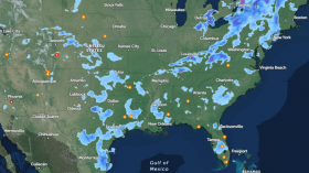
From the eastern Great Lakes to Maine, Iggy is currently producing snow.
The National Weather Service has issued winter weather advisories and warnings due to the persistent snowfall in those areas. The main effect of Iggy for the areas covered by the said warnings and advisories is hazardous travel with closed or slippery roads.
The bulk of Iggy's heaviest snowfall has already occurred.
The best chances of receiving a few extra inches of snow on Friday are in upstate New York as well as northern New England. Several locations from Massachusetts moving towards the west along the New York Thruway and into northeast Ohio may experience some light slushy amounts, The Weather Channel reports.
Friday Forecast for New England
The snow in the interior of the Northeast will last through Friday before ceasing by Friday night.
Northern New England and upstate New York have the best chances of receiving at least 6 inches of snow.
However, the majority of the Northeast will once again experience rain rather than snow from this system. New York City, Baltimore, Philadelphia, and Washington are among the cities still awaiting this season's first measurable snowfall; according to Weather Underground.
Meanwhile, Southwest Airlines announced that there are still several flights on their list that are either delayed, diverted, or canceled until today, January 20. Rebooking is allowed, according to the announcement on their website. No additional charges shall be imposed if the proper procedure has been taken into account. Southwest Airlines also added that those who booked online via their app have the option to conveniently rebook via the app.
Also Read: King Tides At Least 7 Feet High will Slam California Coasts by Weekend, Forecast Shows
Iggy Monitoring Look-Back
Sierra Nevada. On January 15 and 16, Winter Storm Iggy made landfall in California before moving across the mountain West.
The storm intensified the Sierra Nevada's already dense snow cover in California. Iggy and a previous system combined to bring nearly 3 feet of snow to Flagstaff, Arizona, over the course of four days.
At Least 9-Inch Snow. After Iggy dumped 9.2 inches of snow from January 17 to 18, Denver International Airport experienced its heaviest snowstorm of the season thus far. Just east of Denver, where a section of Interstate 70 was closed, reports of a foot of snow, waist-deep drifts, and whiteout conditions were made.
Nebraska's central regions received nearly two feet of snow during Iggy, the state's heaviest snowfall east of the Rockies.
On January 18, Iggy dumped 13.9 inches of snow on North Platte, Nebraska, making it the snowiest day ever in the city. According to weather expert Christopher Burt, the previous record was 12.6 inches, which was set on November 15, 1909, and March 21, 1894.
Iggy dumped at least 6 inches of snow east of the aforementioned region in other Midwest as well as northern Great Lakes regions. This encompasses northern Iowa, the Upper Peninsula of Michigan, southeast South Dakota, northern and western Wisconsin, and southeast Minnesota, The Weather Channel reports.
Related Article: Storm System Moves North but Still Leaves Denver with 8-Inch Snow, Warming Centers Activated as Some Colorado Areas Get 15 Degrees
© 2024 NatureWorldNews.com All rights reserved. Do not reproduce without permission.