Super typhoon Hinnamnor is headed towards the islands off the coast of Japan before turning its attention to the Philippines. A Category 5 super typhoon packs gusts that may reach 320 kilometers per hour.
IN SPACE - SEPTEMBER 20: In this handout satellite image taken by the Japan Meteorological Agency's MTSAT-2 satellite and provided by the National Oceanic and Atmospheric Administration (NOAA), Super Typhoon Usagi heads west-northwest on September 20, 2013 between the Philippines and Taiwan through the Luzon Strait. The storm is the world's strongest of the year so far, with peak winds over 160 mph. The eye is on course to pass over the island of Itbayat, Batanes Province, Philippines on September 21, and the storm will affect the southern portions of Taiwan on September 21 and Hong Kong on September 22.Photo by NOAA via Getty Images
Tropical Storm Hinnamor
Weather forecasters predict that tropical storm Hinnamor, which is presently making its way across the northwestern Pacific as a Category 5 "super typhoon," will make landfall in the Philippines on Wednesday night.
The Philippine Atmospheric Geophysical Astronomical Services Administration (Pagasa) announced on Tuesday that Hinnamnor is packing typhoon-force winds that stretch outward up to 320 km from the center and is now moving 30 km/h to the west.
Storms with sustained winds of at least 157 mph (233 km/h), the highest rating on the scale, are classified as Category 5 typhoons.
According to satellite data, Hinnamnor is currently a tropical storm with winds gusting to 205 km/h. It is anticipated to sustain strength as it advances west and reaches landfall in the Philippine Area of Responsibility (PAR) on Wednesday evening.
The tropical cyclone will be given the domestic name "Gardo" after it has entered the PAR.
According to a dispatch from the state meteorological office, Hinnamnor's eye was last seen around 11 am on Tuesday in the far Northern Luzon region.
It features a 945 hPa core pressure, maximum sustained winds of 165 km/h, and gusts as high as 205 km/h.
The island nation is near the meeting point of the two largest tectonic plates, and a sizable portion of its area crosses the planet's infamous "typhoon belt."
The 7,641-island archipelago in the northwestern Pacific, which is stunning in and of itself, is frequently struck by typhoons (and floods), landslides, earthquakes, volcanic eruptions, and droughts.
Typhoon Belt
Up to 20 storms are thrown onto the Asian nation from the wide Pacific Ocean each year. At least 60% of the country's entire land area, or about 300,000 km2 (116,000 square miles), is vulnerable to these enormous tropical cyclones, leaving a path of destruction in their wake. This region is greater than either Arizona or Nevada.
The greater frequency of these natural catastrophe triggers is due to the archipelago's placement in the route of tropical storms coming in from the planet's largest ocean and its location in the so-called "Ring of Fire."
What makes it the "typhoon belt"? The typhoon belt refers to a vast area in the western Pacific Ocean that, at 165 million km2, is large enough to include all of the world's continents.
Super Typhoon History
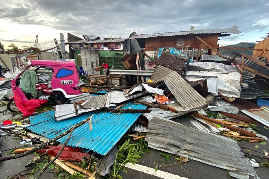
A resident salvaging belongings among debris caused by Super Typhoon Rai after the storm crossed over Surigao City in Surigao del Norte province. Photo by ERWIN MASCARINAS/AFP via Getty Images
Nearly one-third of the world's tropical cyclones form in this "belt" in the western Pacific. Typhoons often travel through the nation from west to north or west as they progress. Long-term climate statistics demonstrate that not only is this region the most active in the globe, but it also experiences the most powerful storms.
With more than 7,300 people either dead or missing, "Haiyan," also known as Yolanda in the Philippines, was the worst hurricane the nation has ever experienced.