The hurricane season is approaching, and rising temperatures are causing a "La Niña" effect in the Atlantic, which might result in bigger and stronger tropical storms.

Extreme Weather Siblings
These cyclical weather occurrences are known in Spanish as "the girl" and "the boy," respectively.
The most well-known of the two, El Niño, is called from "el niño dios," which is how many Latin Americans refer to infant Jesus.
El Niño conditions, including warmer ocean water, are most commonly observed in South America around Christmas, hence the name.
As of mid-May 2022, the brother has departed town, with NOAA anticipating a visit from his younger sister.
The Sister

The arrival La Niña may mean that the North may have a stormier and colder winter while the South may become drier and have warmer temperatures than the average.
La Niña is the polar opposite of its "brother," El Niño, according to Daniel Gilford, a climate scientist at Climate Central.
El Niño provides warmer oceans, which moves the Pacific jet stream south, generating more rain on the East Coast of the United States and higher temperatures in northern regions; La Niña, on the other hand, pulls trade winds south, leading the United States to be hit by a polar jet stream.
"You get less rain and more descending air, which causes temperatures to rise somewhat," Gilford told Earther.
This will result in lower temperatures in Alaska and Canada and drier conditions in regions of the United States such as the South and Southwest.
Also Read: How Previous El Niños Revealed Crucial Information About Climate Change
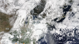
La Niña Storms
We had two highly active hurricane seasons in 2020 and 2021, both La Niña years.
Storms erupted so quickly in 2020 that we ran out of storm names that began with consecutive letters of the alphabet and had to resort to Greek symbols.
That season set a new record with the creation of 30 storms.
According to NOAA's annual reports, both years had intense storms that caused billion-dollar disasters like Hurricane Laura and Hurricane Ida.
But what role does La Niña play in this?
The way air moves over the Atlantic during El Niño years creates strong winds in the high atmosphere, which reduces the possibility of a storm forming in the region.
During the La Niña years, however, this subsides.
"Hurricanes want relatively pure habitats to flourish in... they require warm sea surface temperatures, but they also need a generally quiet and conducive climate in their surrounds," Gilford noted.
Previous La Niña

Due to climate change, 2020 may be among the hottest years ever recorded in spite of the occurrence of La Niña. According to experts, the climate crisis is exacerbating natural events and is causing more frequent extreme weather.
Remember how hot it was in the bottom part of the United States during the La Niña years?
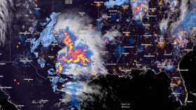
Warmer sea surface temperatures result, providing part of the fuel needed for storms to form and migrate to places like the Gulf of Mexico, Central America's coast, and the United States east coast.
According to Gilford, La Niña conditions are still present this year and may persist until later in the summer.
In the Atlantic, hurricanes are expected to occur.
These weather phenomena are a natural feature of the system; the climate catastrophe did not cause them.
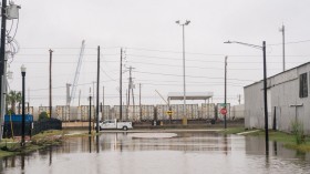
But our changing climate is making them worse. And our national infrastructure is unprepared to deal with such a situation.
Gilford said that being in a La Niña or El Niño year does not guarantee anything, but it gives us a general idea of what to expect. On top of that, climate change is its force.
As storms get more powerful worldwide, higher-category cyclones are more likely to occur.
Storms of Category 3 or above climbed by around 8% per decade from 1979 to 2017, according to a 2020 research.
"As we raise carbon dioxide in the atmosphere, more heat is trapped on the ground... this eventually makes its way down to the ocean, where [warmer] waters give more fuel for storms to form."
Dry Spells
Extreme dry spells are not new; they are a natural part of the cycle in many parts of the planet, and we may expect increased dryness in the United States during a La Niña year.
However, temperatures rise, and precipitation patterns shift due to the climate issue, making droughts worse.
There are already signs of this. The worst megadrought in over 1,000 years has hit the Southwest.
Some of the country's greatest water reservoirs are at historic lows, with bodies being recovered in formerly buried regions under dozens of feet of water.
"It's still something we're trying to figure out," Gilford added.
Related Article: La Niña Expected to Bring Intense Heat Across Southwest States
For more news about the environment, don't forget to follow Nature World News!
© 2024 NatureWorldNews.com All rights reserved. Do not reproduce without permission.
![Venomous Centipede Could be Game-Changer and Save Lives of People with Kidney Disease [Study]](https://1471793142.rsc.cdn77.org/data/thumbs/full/70407/280/157/50/40/venomous-centipede-could-be-game-changer-and-save-lives-of-people-with-kidney-disease-study.jpg)