Tropical Storm Warning Pamela will not only represent a serious threat to Mexico, where it is projected to make landfall as a hurricane but its effects will also be felt in areas of the United States as it moves inland. Pamela is expected to bring heavy rain and flash floods to parts of central Texas before the end of the week. In addition, the interaction of the system with a non-tropical system will increase rainfall even further.
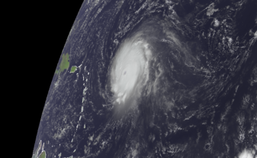
Pamela was a tropical storm that developed last Tuesday morning, with maximum sustained winds of 70 mph. Over the East Pacific, it was spinning 135 miles south-southeast of the southern point of Mexico's Baja Peninsula and heading north at nine mph. Forecasters predict it to weaken to a Category 2 storm before making landfall in western Mexico on Wednesday morning.
However, even if the storm's wind force decreases as it moves onshore, concerns will persist.
"The tropical moisture from Pamela will be pulled northward and combine with a strengthening storm system over the central United States in the coming days, posing a major flash flooding danger throughout areas of Texas," AccuWeather Chief Meteorologist Jonathan Porter said.
Related Article : Developing Storm in Atlantic Coast Can Bring Strong Winds and Flooding in US Coasts
Series of Thunderstorms

From late Tuesday through Tuesday night, a series of severe thunderstorms will be triggered by that non-tropical storm system and its associated cold front over sections of the Plains. Thunderstorms will be strong, with the possibility of tornadoes.
Due to the approaching front, drenching showers and thunderstorms may saturate the soil and cause runoff in certain areas from Tuesday through Wednesday afternoon. As a result, the onset of Pamela's torrential rain may be preceded by isolated occurrences of flash flooding.
The system will lose wind intensity as Pamela moves across the land. However, Pamela will most certainly become a tropical rainstorm as it travels northeastward through central Texas. Forecasters warn that it will remain a potentially dangerous system that may cause life-threatening floods, significant property damage, and travel disruptions.
The developing non-tropical storm system, its blocked front, and moisture from Tropical Rainstorm Pamela are expected to pour heavy rains near the Rio Grande River's Big Bend area to parts of north-central Texas late Wednesday and Thursday night.
Rain may fall so fast that flash flooding in cities and minor streams are anticipated. However, much of the rain might fall in 8 hours or less, with rainfall rates of 2 inches per hour or more possible in some instances.
Rain Needs
Although the region could need some rain, this is likely to happen. According to the United States Drought Monitor, several places have been abnormally dry for a long time, and others are experiencing significant drought.
Areas Affected
Cities affected hardest by extreme rain and floods earlier this year, such as Houston, Corpus Christi, Port Arthur, Texas, and Lake Charles, Louisiana, may miss most of Pamela's rain. Other places to the north and west, on the other hand, may not be so fortunate.
According to Porter, the most severe flooding might occur in the Hill Country northwest of San Antonio and west of Austin. "These are regions where severe flash flooding has happened in the past, particularly on higher land," Porter said.
Dallas, Fort Worth, Del Rio, Kerrville, Waco, and Tyler, Texas, are among the cities at risk of flash floods in the middle to late week.
Beyond the Dallas/Fort Worth area, flash flooding is possible in southeastern Oklahoma and northwestern Arkansas this week.
"Water may swiftly rise when rainfall rates increase, especially near streams, other waterways, and low-lying regions," Porter warned.
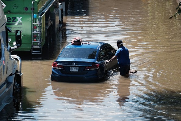
Forecasters advise drivers to avoid driving through flooded regions since the water level may still be rising and the flooding may be deeper than it seems. In addition, road surfaces can be washed away by flooding in rare situations.
The first locations to flood are likely to be low water crossings, underpasses, and regions with inadequate drainage. In this circumstance, certain vulnerable sites near streams and rivers will also be flooded.
"As bad as the rain and flooding threat is, only Pamela's quick forward motion can avert much more rain and a widespread flooding calamity," said AccuWeather Senior Meteorologist Rob Miller.
Significant Risk
Flooding rains pose a significant risk to life and property in the United States.
Dry air is expected to flow southeastward across areas in the path of Pamela's rain by the end of this week and into the weekend. Because of the dry weather, the earth will soon dry out, allowing streams and rivers to retreat.
For more climate and weather updates, don't forget to follow Nature World News!
© 2026 NatureWorldNews.com All rights reserved. Do not reproduce without permission.


