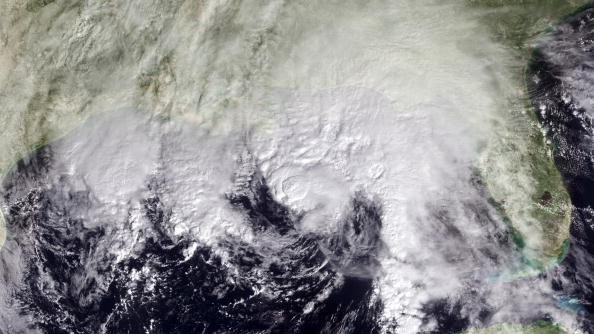
The newest tropical storm of the 2021 hurricane formed over the eastern Atlantic on Wednesday afternoon, earning Victor's second-to-last designation on the initial list.
Tropical Depression 20 had been assigned to the system, which formed Wednesday morning before swiftly developing throughout the day. It was spotted late Wednesday morning a few hundred miles south of the Cabo Verde Islands, with maximum sustained winds of 40 mph.
Strengthening storm
According to meteorologist Randy Adkins, conditions will be ideal for strengthening during the following few days.
"There will be a small window for the storm to build into a hurricane," Adkins said. "However, rising wind shear and drier air will likely revert this trend, with a gradual reduction of wind energy anticipated later this weekend into next week." "As it stands now, this storm will not represent a direct threat to land," Adkins said, referring to the Azores, a group of islands in the Atlantic approximately 950 miles west of Portugal.
According to forecasters, Tropical Depression 20 is expected to develop south to southwest, steering winds over the central Atlantic. This weekend into next week, these breezes will bend the system northward across the east-central section of the basin, well away from the Caribbean Islands, Bermuda, and North America.
Read also: Meteorologists Predicts that the Atlantic Hurricane Season Will Inevitably Be More Aggressive
Keeping an Eye
Forecasters have been examining two regions of unsettled weather over the eastern Atlantic: the newly created depression.
Another region of unsettled weather, sometimes known as a tropical wave, seemed to be poorly structured as of Wednesday, a few hundred miles west of the tropical storm and several hundred miles southwest of the Cabo Verde Islands. Because of the lag in the organization, this more western tropical wave may not develop into a tropical depression or storm.
Because this more western feature was more likely to reach the Leeward and Windward islands around the early or middle part of next week, the lack of development thus far is essential for the Leeward and Windward islands. In addition, due to the delayed formation, increased wind shear in the Leewards and Windwards might completely disrupt the storm's progression.
"In the aftermath of Hurricane Sam, a large region of wind shear is expected to rise this week and remain," meteorologist Bernie Rayno said. Then, strong breezes will emerge at mid-levels of the sky and extend from the west and southwest.
Wind Shears
"This band of wind shear will stretch from the Gulf of Mexico and the Caribbean to the central Atlantic, peaking this weekend," Rayno said. As a result, any tropical feature attempting to form or move inside the ring of wind shear would most likely fail.
Aside from Sam, what was formerly Peter appears to have missed its chance to regenerate on the other side of the Atlantic. As a result, the organization of a small swirl of clouds southwest of Peter will be observed, although wind shear may preclude any significant disturbance evolution.
Over the next week, the area stretching from the Caribbean to the Atlantic coasts of the United States might be a source of concern.
Atlantic Hurricane Season
According to early indications, one or more low-pressure zones may form from the Caribbean through the Bahamas and maybe as far north as the Carolina coast next week. This large area of low pressure can develop into a tropical system, so keep an eye on the spot. Wind shear that persists or shifts may act as a barrier to fast development.
A zone stretching from just off the southern coast of the United States to the Bahamas might be the most likely location for a system to form.
"An expected southern dip in the jet stream over the eastern United States may pick up any low pressure in the southwestern portion of the Atlantic basin and drive it northward next week," Adkins added. However, if the jet stream does not take up this low center, presuming it develops first, chances for tropical development might improve by the following weekend.
Regardless of tropical development in the southwestern Atlantic basin, a large zone of unsettled weather conditions with clouds, rain, and thunderstorms from the Caribbean to the Bahamas and the eastern United States and coastal seas may occur.
Because Victor is expected to develop in the southern Atlantic this week, Wanda is the sole name on the pre-selected list for 2021. The Atlantic hurricane season will go through November 30.
For more climate and weather updates, don't forget to follow Nature World News!
© 2026 NatureWorldNews.com All rights reserved. Do not reproduce without permission.


