Mindy's moisture plume will contribute to soaking showers and thunderstorms throughout the southeastern United States through Friday.
Downpours can be intense and persistent, dumping 3-6 inches of rain and causing flash floods in some areas by the end of the week. Rainfall levels will be in the range of 1-2 inches over the country.
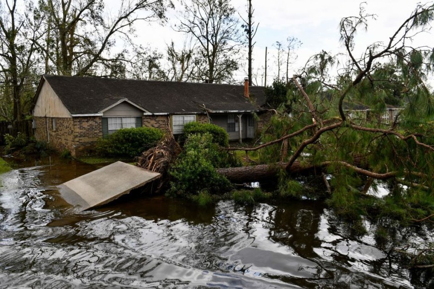
Flooding is expected to continue through Friday in the metro regions of Tallahassee and Jacksonville, Florida, Savannah, Georgia, and Charleston, South Carolina.
Thankfully, most of the rain will fall east of the areas of Louisiana impacted hardest by Hurricane Ida in late August. However, according to PowerOutage.us, more than 300,000 utility customers in southern Louisiana were still without power on Wednesday evening.
Torrential Rains in the South
On Tuesday night and Wednesday morning, torrential rains struck parts of northern Georgia and upstate South Carolina, causing isolated flash flooding. Tropical moisture pouring northward from the Gulf of Mexico and the vicinity of an old stalled frontal zone contributed to the downpours.
Seas and surf may be rough due to the tropical storm, especially in the vicinity of thunderstorms until Thursday evening.
Wind Shears

Although wind shear restricted development earlier in the week, the warm seas beneath the system helped it grow.
"On Wednesday, the core of this [system] was over some of the Gulf of Mexico's deepest warm water," AccuWeather Hurricane Expert Dan Kottlowski said.
Warm waters spread to the Gulf's depths, with water temperatures in the middle to high 80s F in parts of the central Gulf. Conditions are deemed suitable for tropical growth when water temperatures are 78 degrees or above. The water is less likely to be cooled by the swirling winds on the top when it is warm through a deep layer.
Mindy's Trajectory
As Mindy moves over land, its wind intensity will decrease, and it is forecast to become a tropical depression before shifting back overseas later this week.
From Friday into the weekend, dry air is expected to blow through the Southeast.
Over the weekend, steering winds are expected to move this feature out into the western Atlantic, where it will pose less of a threat to the United States.
Extreme Weather
Larry will remain the strongest tropical cyclone on the charts in the Atlantic through Friday night, ahead of a near encounter or landfall on the Canadian island of Newfoundland.
From this weekend until early next week, a new danger might emerge in the waters around Mexico and Central America, but the trade winds' speed may hold the system too close to shore, limiting its ability to develop further. Instead, winds may keep pushing it westward over the continent.
In the western Gulf, there is a low likelihood of development through early next week, but there will be a greater potential for tropical development when the system moves over land and into the Pacific later next week, according to Kottlowski.
Tropical Surges
Tropical waves will continue to sweep westward from Africa further east into the Atlantic. As a result, there's a potential that a more powerful wave in the train latches on and steadily grows in the region of the Cabo Verde Islands, which are located off the west coast of Africa, this weekend to early next week.
Atlantic Hurricane Season

The 2021 Atlantic hurricane season had generated 13 tropical storms as of Wednesday, Sept. 8, with five of them strengthening into hurricanes. Three of those hurricanes intensified into significant storms (Category 3 or higher).
With hurricane season just halfway through (Sept. 10), plenty more tropical storms, hurricanes, and major hurricanes are expected this year as the year progresses at a faster-than-average rate. There are 14 named storms on average over a season, including seven hurricanes and three major hurricanes.
For more climate and weather updates, don't forget to follow Nature World News!
© 2026 NatureWorldNews.com All rights reserved. Do not reproduce without permission.


