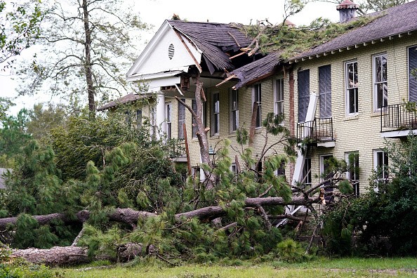
Residents in the Northeast who are still recuperating from the devastation wrought by Tropical Storm Ida last week should be on the lookout for showers and thunderstorms this week, which might result in further flooding.
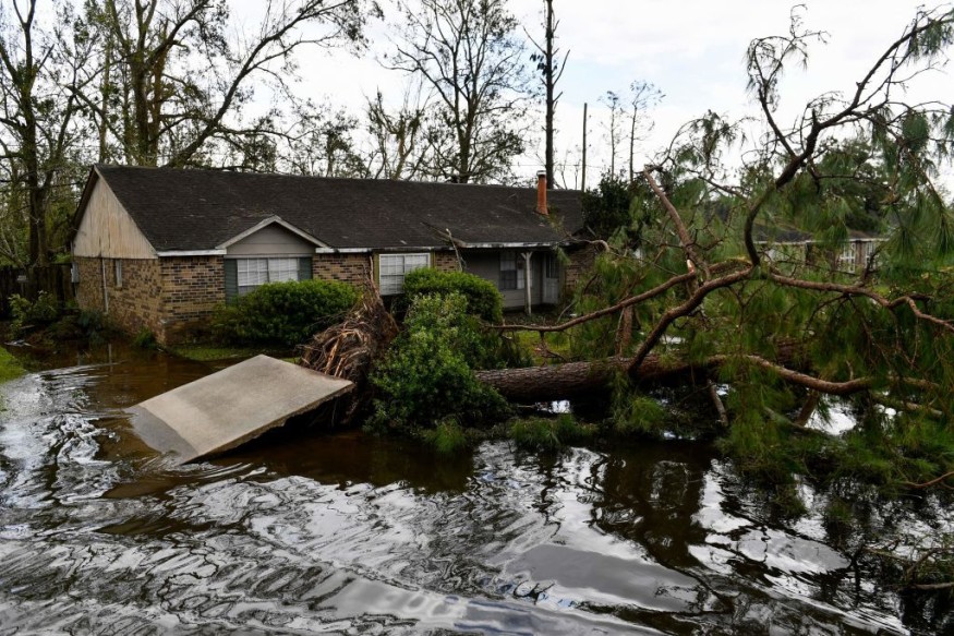
Following Hurricane Ida, which caused record and devastating floods as well as extreme weather over the Northeast last week, the region experienced a period of relative calm for several days. While some areas experienced a brief spell of rain over the weekend and early this week, Ida is expected to provide primarily dry conditions until Tuesday.
According to The Associated Press, the former storm caused at least 50 deaths from Connecticut to Virginia by unleashing heavy rains that drowned basement apartments in New York City, caused homes to collapse in New Jersey and flooded a major roadway in Philadelphia.
Forecast

Meteorologists predict that the relatively quiet weather pattern will end by the middle of the week. On Wednesday, the same cold front that brought severe weather to the Great Lakes Tuesday will move into the Northeast, bringing more storms.
Showers will reach first in Ohio, northwest Pennsylvania, and western New York on Wednesday morning. Thunderstorms may develop during the day as the front moves over the Northeast.
"Parts of the Northeast will have the potential for additional downpours and strong gusts for the first time since Ida's devastating flooding," said meteorologist Dean Devore.
Rain Level
Rainfall levels of approximately half an inch are predicted over the region, with higher isolated amounts of around one inch possible, especially if thunderstorms develop. The greatest rain is expected when the storm moves across the inner Northeast and the I-95 corridor from midday Wednesday to late Wednesday evening.
While an inch of rain on a typical late-summer or early-fall day is hardly excessive, the recent heavy rain across the Northeast has made many regions more vulnerable to floods. New York City has received more than 300 percent of its average rainfall since August 1. For example, Boston and Washington, D.C. have received more than 200 percent of their average rainfall.
When Hurricane Ida passed across the region last week, totals in several other regions skyrocketed. So even if less than an inch of rain falls during three hours in the Philadelphia suburbs and parts of New Jersey, the almost 10 inches of rain poured last week would make it conceivable for certain places to flood on Wednesday.
Remaining Vigilant
Residents should be on the lookout for any alerts issued in their area. In addition, due to downpours limiting visibility and generating ponding on highways, motorists can expect delayed driving.
Developing Thunderstorms
Thunderstorms are predicted to develop throughout the northeastern United States and southern Quebec later on Wednesday, although there may be heavier wind gusts. Even a 30 mph wind gust can topple a vulnerable tree, especially given the region's saturated soil after a particularly wet month.
This front will also be responsible for diverting Hurricane Larry away from the United States as it pushes off the New England coast later on Thursday. However, even if Larry does not make landfall, the powerful storm will deliver high waves and severe rip currents to the mid-Atlantic and New England beaches in the second half of the week.
"Beachgoers are advised to abide by the limitations imposed by officials. With the number of lifeguards at most beaches reducing after Labor Day weekend, the degree of risk for swimmers will rise, especially with Hurricane Larry at sea, "Senior Meteorologist Alex Sosnowski of AccuWeather said.
Cold Air
Behind the severe weather, a pleasant rush of colder air will sweep through the eastern United States, dropping temperatures as much as 5 degrees below normal for early September across the Great Lakes and most of the Northeast. Dew points will also fall, resulting in less humid conditions throughout the region.
Parts of the I-95 corridor from New York City to New England and coastal sites along this region are anticipated to have near-normal temperatures. For New York City and Boston, high temperatures are expected to be about 80 degrees.
On Thursday, the chilly air pouring across the warmer Great Lakes may allow for some lake-enhanced showers and perhaps the development of a waterspout. On Friday, though, high pressure is forecast to sweep into the Ohio Valley, bringing dry weather just in time for the weekend.
For more climate and weather updates, don't forget to follow Nature World News!
© 2026 NatureWorldNews.com All rights reserved. Do not reproduce without permission.


