Recent satellite images of Alaska's Yukon Delta show that the Arctic is getting greener and lusher, which is really bad news for the arctic area and beyond.
The photos, taken on May 29 by the US Geological Survey's (USGS) Landsat 8 satellite, showed significant vegetation in prior arctic conditions, providing further proof of global warming.
According to Dr. Uma Bhatt, an atmospheric science professor at the University of Alaska Fairbanks, the bursts of plants and shrubs across what is normally a frozen tundra environment, are connected to sea ice decrease as the world is getting warmer.
Alaska's Yukon Delta
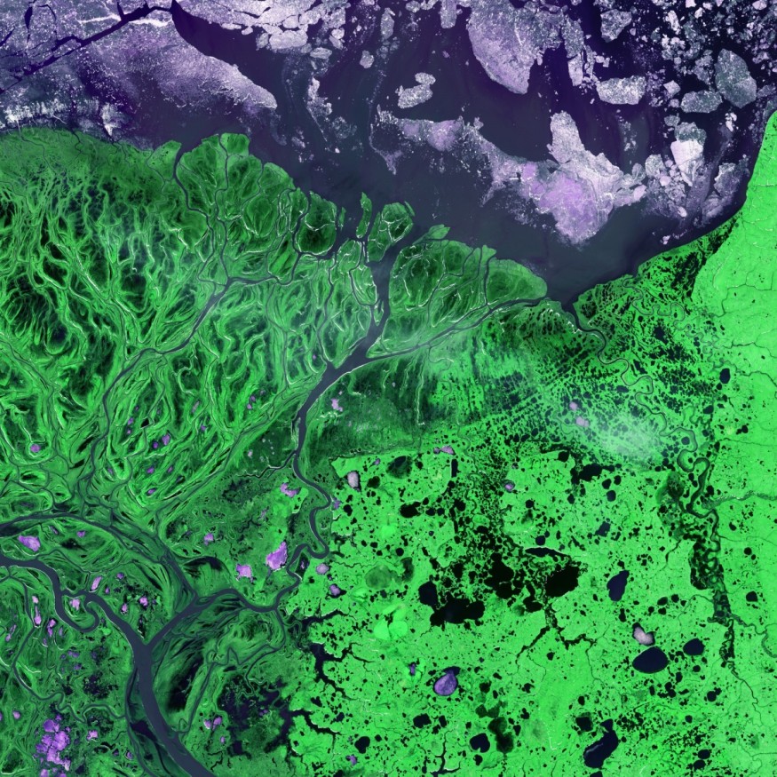
In Southern Alaska, the Yukon-Kuskokwim Delta is one of the world's largest deltas in the world. The delta is of great scientific importance since It is a vast transitional area between land and water, freshwater rivers and salty sea, tundra, woodland, and marsh. It is also subject to significant seasonal fluctuations, from winter snow and ice to spring flooding and an enormous amount of sediment transported into the Bering Sea, followed by fast plant growth in summer.
According to Lawrence Vulis, a PhD student at the University of California, Irvine; the delta would have seemed considerably more flooded just after the melting of snow and ice a few weeks before. In the stream gauges and satellite photos, the majority of the water has since subsided. Nonetheless, the flooding was recent enough that there was still a lot of ponding on May 29. As the summer progresses, the floodwaters will continue to recede and the marshes will green up with flora.
The delta was not always this way. The current Yukon Delta is just a few thousand years old. Because of its young age, the delta might very well appear different in the future. "The Yukon and other Arctic deltas are thought to be particularly vulnerable to climate change," Vulis explained, "Due to the roles of permafrost and ice in shaping these deltas."
Permafrost is defined as any ground that has been totally frozen 32°F (0°C) or colder for at least two years. These permanently frozen fields are particularly frequent in mountainous areas and at higher latitudes around the North and South Poles and when a permafrost melts, additional greenhouse gases are emitted.
This will then cause a snowball effect. The worst thing, at least in terms of our civilization, is the continued loss of ice and the resulting rise in sea levels and the near extinction of other arctic species.
What you can see in the satellite image
Color satellite images, unlike photos, are data-crunched representations of many wavelengths of light, including those not visible to the naked eye. Instruments aboard satellites passing overhead take data of different bands of the electromagnetic spectrum for landscape photos like those of the Yukon Delta.
While the image might be regarded a piece of art, there are certain advantages to seeing the land in this manner. For example, regions of living vegetation (green) may be clearly distinguished from land that is barren or includes dead vegetation (light brown) from the network of sediment-rich rivers and ponded flood water (dark brown).
In the detailed view above, they are notably visible on each side of the river channels. The light-brown regions are largely wet sedge meadows; they seem brown because much of the vegetation is dead from previous year's growth. The vegetation is shrub-tussock tundra away from the delta.
© 2026 NatureWorldNews.com All rights reserved. Do not reproduce without permission.


