With 11.44 inches of rain, May 2020 was the wettest month on record; over 9 inches dropped between May 18 and 22, when an upper-level low became cut off from the jet stream and spinning in place, circulating a firehose of Atlantic precipitation toward the Appalachians for five days.

Rain Levels

Just 0.73 inches of rain has fallen so far in May, as of Tuesday afternoon. If the month were to end today, it would be the second driest Can on record, trailing just 0.63 inches in 1914, two years after official records for the site began.
If spotty showers and storms pump enough rain into the official gauge at the airport over the next six days, this could be just the second in weather history to conclude with less than an inch of rain overall.
Late Monday, Blacksburg saw only such a swift shower, followed by a brief rain downpour Tuesday afternoon, measuring 0.76 inches and bringing the month's total to 1.87 inches. For the month, that's still more than an inch and a half below average.
Drought
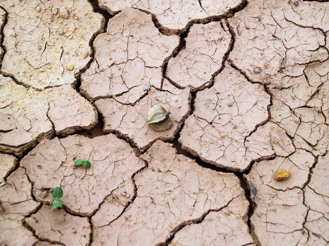
Despite some spotty rain over the last few days, the area is on the brink of being drought-stricken.
According to the most recent U.S. Drought Monitor, "abnormally dry" conditions, the first level of drought, have reached as far west as the eastern side of the Blue Ridge since originating in North Carolina and Southside Virginia.
Following the wettest year on record in 2020, as well as a wet winter marked by heavy freezing rain and wintry mix, our country is unlikely to see cracking dry mud in rivers or much lower water tables anytime soon.
However, even a few weeks of drought may have a detrimental effect on crops and gardens and raise the risk of wildfire.
Related Article : For Millions of People, Memorial Day Weekend Could be Ruined by Bad an Incoming Storm
Weather Flow

This month, our weather trend has changed from a cool but dry northwest flow out of Canada to a warm, dry high-pressure system forming overhead. The wettest atmosphere has been limited to the southern United States.
Rain Over the Weekends

We've reached the point that a widespread soaking rain is desperately needed, while many of you don't want it to fall on your Memorial Day weekend.
There is no clear indication of a weather trend that will bring widespread heavy rainfall to our country in the coming days. Instead, cold fronts will push into humid, moist air, perhaps resulting in occasional showers and storms.
It could rain on you while your friends two miles away get sprinkles or nothing, or it could rain on you while your friends two miles away get nothing.
On Monday and Tuesday, we saw this with the arrival of a "backdoor" cold front, one that came in from the northeast rather than the more usual west or northwest.
On Monday evening, a heavy cluster of showers tracked southeast from Lexington to Lynchburg over the Blue Ridge. A system of locally heavy rain dived southeast from Lexington to Lynchburg. However, several other areas did not see a decrease.
Similarly, storms raged along and just west of Interstate 81 on Tuesday, but the rest of the state was spared.
Another cold front moving in from the northwest late this week will act as a focal point for further showers and storms over at least part of Memorial Day weekend, but widespread rain of more than an inch or two remains impossible.
It's far too early to predict whether summer will be hot and sunny, sticky and stormy, or anything in between. But it doesn't seem that we'll be as drenched as we were when we arrived in spring from winter.
For more climate and weather updates, don't forget to follow Nature World News!
© 2026 NatureWorldNews.com All rights reserved. Do not reproduce without permission.


